 |
| Road between the Cohos Trail and Rudy's Campground at Clarksville Pond |
Day 3 of my final trip on the NET-Cohos route, and I set out before dawn once again in order to avoid ATVs. I had a fifteen-mile hike to "Happy Corner" and I wasn't quite sure how much of it was open to ATVs. Impossible to tell from the trail map. It was nearly a mile back to the Cohos Trail from the campground, and the first thing I noticed was that the signs at the junction had been broken and knocked to the ground. Perhaps the ATVs I heard riding around in the dark.
 |
| These signs were standing the day before |
I set out to cover as much ground as possible early in the morning and get myself off the ATV tracks. The trail was deeply rutted and the vegetation along the sides was covered with thick road dust.
 |
| Deadwater Trail (ATV track) |
Eventually the rutted Deadwater Trail turned into the Deadwater Loop Road for a good ways before the Cohos turned onto Cedar Stream Road.
 |
| Deadwater Loop Road |
There were signs indicated that ATV access was only local, and I relaxed a little. I didn't realize how much the threat of an ATV suddenly screaming up the trail had put me on edge.
 |
| Deadwater Stream crossing, Cedar Stream Road |
It turned out that I had no issues with ATVs all day. That was probably in large part because it was Monday and the weekend crowds were gone. Also, the weather forecast included rain.
 |
| Lake Francis from Cedar Stream Road |
The Cohos follows Cedar Stream Road for about six miles along the south side of Lake Francis, though it was a mile or two before the lake could be seen from the road. The first glimpses of the lake were through sporadic camp clearings, then there was a nice overlook right from the road. Beautiful.
 |
| Fall colors on Cedar Stream Road |
This wasn't a bad road walk, especially with the fall colors. Before long there was an access point from the road where you could walk down to the shore. Looked like the reservoir level was pretty low. I took a nice long break. There was a cell phone tower on a hill above the opposite shore and I got a great signal.
 |
| Taking a break off Cedar Stream Road |
The clouds were ominous and the radar showed a big slug of rain just missing me to the north. The next afternoon I would run into a southbound hiker who commented on how much rain had fallen the day before. It fell on her, but not on me. I got showers a few times during the day, but it never rained hard or for very long.
 |
| Lake Francis |
After the break it was back to the long road walk. For some reason, I kept seeing dead shrews in the road. Not run over, just dead. I once asked a wildlife biologist about finding these creatures dead and apparently unharmed, and he said that they have a very short lifespan and just die a lot. I've never seen so many dead ones on the same day, but I don't usually walk down roads for fifteen miles, either.
 |
| Mountain Maple |
Cedar Stream Road had had very little traffic. Only a few pickup trucks passed me, and this end of the road seemed pretty isolated. A quiet Monday morning and a pleasant walk The road was in the maple zone, so there was lots of fall color and lots of time to enjoy it. Mountain Maples were low and often orange to red. This is a small tree often growing in a clump I've never seen in southern New England.
 |
| Red Maple |
Red Maples, true to their name, were consistently a deep red. The edges are jagged and frayed. I think of it as a weedy tree that makes me suffer every spring when it pollinates.
 |
| Sugar Maple |
The regal Sugar Maple was a variety of color ranging from gold to orange to red. I think of its leaves as being more ornate, never frayed at the edges. I hadn't seen any Striped Maple for quite some time. No idea why.
I kept an eye on the gps track stored on my phone as the trail approached the east end of Lake Francis because there was a critical left turn. Good thing I did, because I don't think the turn was marked in any way. Just a bit of a dirt road veering off to the left. I'm so glad I had the gps track. Without it, I would have explored that turnoff as the likely one, but with the gps track I KNEW it was the correct turnoff.
 |
| Off the gravel roads!!! |
The Cohos rounded the southeast corner of the lake and turned onto Lake Francis Trail, which finally turned off of the gravel roads. Yes! Walking down the woodland path put a smile on my face. It was so nice after walking on gravel roads for the past two days.
 |
| Lake Francis "Six-Mile View" |
After a bit, the trail arrived at Six Mile View, where you can look down the long axis of the reservoir, a full six miles. A big pile of driftwood was piled up into the trees far from shore, driven and piled up by some pretty good waves that are created by west wind, presumably when the water level was much higher.
There were also strand lines parallel to the shore. It looked very much like the shore of Long Island Sound where you get strand lines at various high tide levels. I caught myself keeping an eye out for crabs and other ocean creatures, just out of habit.
 |
| Strand Lines on Lake Francis |
After a nice long break for lunch, I continued up the Lake Francis Trail, an easy walk, and started to hear water roiling down the steep hill to my left. It sounded like a big waterfall, but I couldn't see it. This continued for a good ways. It wasn't a waterfall, it was the Connecticut River. I quickened my pace, eager to finally see the Connecticut River once again during this walk. The last time was a few hundred miles to the south in Hadley, Massachusetts, where the New England Trail crosses the river. After a morning of kayaking the nearby oxbow lake, we had kayaked across the river, I got out with my pack, and my husband towed the kayak back across the river. Such fun!
 |
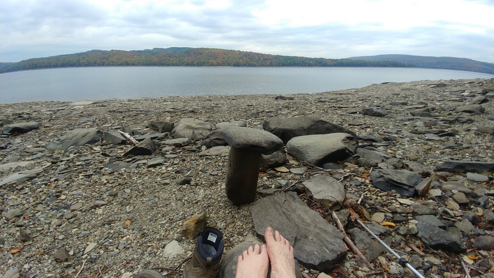
| Fishermen on the Connecticut River |
The trail abruptly came out onto a bridge over the river. Wow! This was not the Connecticut River I was used to. It was young and wild and free. The version I'm used to in Connecticut is vast and tidal. A couple of guys were fly fishing to one side, so I went over to the other side and had a sudden, inexplicable need to take off my boots and put my feet into this Connecticut River. Sweet!
 |
| Connecticut River above Lake Francis |
After a bit of a road walk and then a turn onto a heavily eroded ATV trail (empty on a Monday), I came out onto the back side of Young's Store. Second lunch! I had a nice cold drink and an ice cream to start, threw an sumptuous Italian Combo sandwich in my pack, and cross the street over to Mountain View Cabins and Campground.
 |
| Coming up on Happy Corner |
The proprietor let me have my pick of tent sites (all were empty). It was a pretty good hike up the hill to the tent sites, but the fifteen mile walk was over. I set up the tent, had that Italian combo at the picnic table, and took a shower. A startled deer jumped away from my campsite when I returned from the bathhouse, snorting and leaping. Deer rarely bother with all the theatrics in Connecticut. They just walk away a short distance into the trees, clearly annoyed, and turn around an look at you with disdain.
After inventorying my food supply, I determined that I needed something like 3500 more calories in my pack, so I headed back down to Young's general store, where I got a box of Triscuits, a box of NutriGrain bars, some Peanut M&M's, local fudge, and another sandwich for dinner. All set for the rest of the journey. The Triscuits packed and carried really well. The Nutrigrain bars turned to mush but still tasted OK.
 |
| Mountain View Campground |
Once again, I was able to hang out in the laundry room and charge my phone. Nice.


No comments:
Post a Comment