If you're going to hike across New England all the way from Long Island Sound to Canada, it helps to have an appreciation of the working landscape. Because of course you're not walking across a vast pristine wilderness. Millions of people live and work here, and people have been managing the landscape for thousands of years.
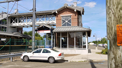
The four-mile road walk from Long Island Sound in Guilford sets a nice baseline. Here is Southern New England, land of busy commuters. Shortly after leaving the shoreline behind, the blue blazes of the New England Trail lead you inside the Guilford Train Station and up some stairs in order to cross over the commuter line railroad tracks. Hop on a train here, and you can be at Grand Central Station in Manhattan in an hour or so. The trail then takes you past houses and stores and museums to cross Route 1 (the famous colonial "Post Road" between New York City and Boston) and over I-95. A whole lot of infrastructure to get people from houses to jobs. Watch the cars zipping by and be happy you're hiking and not commuting to work.
 |
Trap rock ridges absorb water for drinking water reservoirs
(Trimountain and Ulbrich Reservoir) |
Through most of Connecticut and the southern half of Massachusetts, the New England Trail follows the Metacomet Ridge, which is all trap rock. This ridgetop hosts a narrow ribbon of green cutting through the suburban sprawl. The main reason it's green, and not a bunch of McMansions with views, is because people long ago realized how effective the trap rock ridges were at collecting and filtering drinking water. Water drains right through the hard basalt (surprisingly) and is collected in reservoirs maintained at the base of the ridge. The MDC lands? That's Hartford's water supply. The porous nature of the rock is also why finding water is one of the biggest challenges of backpacking the New England Trail - there's rarely any water up there on the ridge. At any rate, you're not walking through some nature preserve per se. You're walking across a drinking water collection and filtering system for all those homes in the valley below.
 |
| Tilcon Quarry at Mt. Chauncey |
You can't escape the massive trap rock quarries while hiking the New England Trail. They become landmarks. The hard but brittle trap rock is crushed and used in construction. If you're hiking during the week, you might be able to watch the operation in progress. Giant trucks that look like ants down below. Are the quarries ugly scars upon the landscape, or impressive examples of human ingenuity? Maybe a little of both.
Cell phone and radio towers are another common occurrence along the trap rock ridges. That's why there's always a really good cell phone signal up on the trap rock. Go ahead ... call up an Uber to the nearest hotel for the night.
 |
| Rich farmland along the Connecticut River in Massachusetts |
Moving north along the NET, there are scattered farms down below. Some of the richest farmland seems to be in the Connecticut River Valley. The old M-M Trail used to go through the middle of a cornfield after crossing the river, but that section was sadly closed after the trail gained federal status as the New England Trail.
 |
| Ski facilities at Ragged Mountain in New Hampshire |
Outdoor recreation becomes more economically important as you head north into New Hampshire, and you're going to share the forest with other types of users. There are several ski slopes, including the ones at Mt. Sunapee, Ragged Mountain, and Dixville Notch in New Hampshire. This is one of those winter activities that tends not to impact seasonal hikers very much, and you get some nice views where they've cleared out the trees.
 |
Following snowmobile trail 5N through the New Hampshire gap
|
Snowmobiling is another form of income-generating recreation for New Hampshire, and there are miles of official snowmobile trails crossing the state. The NET-Cohos route through New Hampshire often follows a snowmobile trail. For the most part, snowmobilers and hikers are on the trail in different seasons and there's no conflict.
 |
Deer & Turkey registration station
Mt. Sunapee
|
Hunting and fishing are another type of recreation you might run into along the trail. In some cases, the trail might cross sportsman club land with permission, as the New England Trail does in Guilford, or the SRK Greenway does on Ragged Mountain. Don't be surprised if you hear gunfire there, or at some of the shooting ranges nearby. Most hunting takes place in late fall when the leaves are brown, but there are different seasons for different types of hunting, and I start wearing blaze orange once the leaves start turning. I had a group of guys hunting bear pass me at one point on the M-M Trail in New Hampshire. There's no bear hunting in Connecticut, which explains why that one bear was so relaxed while checking out my empty tent in Simsbury. There's deer hunting in Connecticut, though, and I once had a backyard poacher shoot a deer near me while backpacking before firearm season had started. The lung-shot deer fled maybe 100 yards through the state forest and dropped beside the trail just before I got to it. I was never so happy to be wearing blaze orange.
 |
Active logging, with windmill on the horizon
Cohos Trail at Kelsey Notch |
Windmills capture the wind's energy along some of New Hampshire's ridges. There aren't very many, so they've never bothered me. If they were all over that might be different. A section of the Cohos Trail passes so close to one that the sound of the blades cutting through the wind was audible.
Logging is a major industry, of course. You don't see much logging along the NET because the traprock ridgeline is usually part of a drinking watershed or park. But there's lots of active timber management as you pass through the northern forests. More interesting might be the remnants of earlier logging, especially the old logging railroads and network of fire towers.
 |
Smarts Mountain Fire Tower
Appalachian Trail
|
The old fire towers are often still standing and are now scenic attractions for hikers. It's easy to forget how important the fire towers once were. Fires started by trains or fireplaces would burn vast areas of timberland, along with fancy mountain hotels. So loggers and the hotel people got together and worked to create a network of fire towers.
 |
Old logging railroad through the White Mountains
Nancy Pond Trail near Mt. Carrigain |
The old logging railroads are especially noticeable if you take the eastern gap route option through White Mountain National Forest near TriMountain and Mt. Carrigain. The amount of work that went into building the railroad system in the White Mountains is amazing when you consider that the forest was clear-cut once and that was it. The tracks were no longer needed.
 |
Old stands of Paper Birch that sprouted up after logging fires
Cohos Trail in the Kilkenny |
Another reminder of the previous logging and the fires that were created is the type of trees growing. The combination of dry logging slash left on the ground and sparks flying out of trains lead to some big fires in the White Mountains. After the fires, hillsides of Paper Birch sprouted. You can see this walking the Cohos Trail in the Kilkenny area. Paper Birch doesn't live very long, and it doesn't resprout very well in a growing forest, so there are big stands of old, dying Paper Birch along the trail.
 |
ATV road, Cohos Trail
|
Once you get pretty close to Canada in the Pittburg area, it is suddenly ATV land. There are ATV roads and ATV rentals and ATV clubs. Cottages and campgrounds are advertised to accommodate ATVs. It's a completely different scene from ATV usage in Connecticut, which is typically a 14-year old boy thrill riding illegally on someone else's property and ripping up hiking trails. These New Hampshire ATVs are ridden legally by men and women of all ages and they often have roll cages for safety. Some locals told me they didn't personally like the ATVs, but it brought in lots of tourist dollars. It's the same view as someone who makes a living off of logging or digging a quarry might have. They don't necessarily like seeing all the trees cut, but it pays the bills.
A part of the Cohos Trail currently follows ATV roads, but there are thankfully plans to reroute that, because hiking and ATVs are not compatible. The noise and dust and fear of being struck by a vehicle is exactly what hiker-types are typically trying to avoid, which is why they're hiking and not just walking down a street. There are other areas along the Cohos where you hear the ATVs, sadly, even though the trail is not following an ATV road. Both times I was above Dixville Notch, for example, the experience was marred by the sound of a single ATV down below. But what can you do. I guess you just have to expect the sound of ATVs at the north end of the trail the same way you know you're going to hear traffic noise in Connecticut.