 |
Mt. Monadnock from our Airbnb apartment
(Click photos to enlarge) |
Last day on the New England/M-M Trail! As we strolled out of our Airbnb apartment with a breathtaking view of Mt. Monadnock and vivid October leaves, our host Jo came past and said she had left fresh banana bread right outside our door in the hallway. I went back in and grabbed the steaming hot bread and we devoured a piece of this unexpected treat even though we'd already had breakfast. Pretty sure we were going to burn off those calories.
 |
| Monadnock from our Airbnb apartment the night before |
This was our first time trying Airbnb and it worked out pretty well. Previously we had stayed at local hotels and had good experiences, but we wanted to try something different. For slightly more than we paid for a room before, we got a full apartment with a living room, kitchen, bedroom and bathroom and a view of Monadnock. Nice!
 |
M-M Trail in orange (Royce/White Arrow Trails)
Monadnock Sunapee Greenway (Dublin Trail) in Yellow |
The way up Monadnock was predetermined: The M-M trail follows Royce Trail up to the popular White Arrow Trail near the Halfway House, then follows the White Arrow Trail up to the top. But what was the best way down? I settled the question by asking Google, and was advised that Dublin Trail was a good choice. And, as fate would have it, Dublin Trail is also the beginning of the Monadnock-Sunapee Greenway trail that goes another 50 miles to the north to Mt. Sunapee. Sweet! If I went down that way, I'd have the first couple miles of that trail done in case I wanted to hike that trail some day.
 |
| A gentle start on a crisp fall morning |
My husband dropped me off in the 'no parking' zone where the M-M crosses Rt 124 and drove off towards the Dublin Trailhead. He had surprised me by wanting to hike up Monadnock, too. Usually he golfs while I'm out hiking. "Go slow!" I told him. "Make it last. That's what I'm going to do." I didn't want to feel rushed.
 |
| Fall color at the base of Monadnock |
The trail started out easy and was worn just enough so you knew where it went without having to deal with erosion or crowds. The lack of parking on Rt 124 keeps most people off of this trail, and some of the maps don't even show it. The best place to park for the Royce Trail is probably the north parking lot for Gap Mountain, which adds an easy 0.8 miles to the route each way.
 |
| Quote from Henry David Thoreau at the Visitor Center |
From Rt 124 to the top, the M-M gets progressively steeper and the footing more difficult, so that by the end you are essentially rock climbing. The beginning was an easy morning stroll, but I still made a point to slow myself down. A quote by Thoreau stuck in my mind:
"They who simply climb to the peak of Monadnock have seen but little of the mountain. I came not to look off from it, but to look at it."
 |
| Hobblebush |
And at one point is suddenly struck me that as eager as I was to complete the NET/MM, I suddenly didn't want the trip to be over. I wanted to savor the last few hours and make them last. Everything was perfect. The day was crisp, cool, and clear, but not too windy. The leaves were at their peak. The cast on my broken hand had been replaced with a much smaller splint that allowed me to bend my wrist and was far more comfortable.
There had been a hard frost over night and it was probably 40 degrees when started, so I had a lot of layers on. As I walked up the steeping hill, one layer after another came off. Finally I stopped and switched from jeans to a pair of shorts I didn't expect to use but packed anyway.
 |
| End of the less-traveled Royce Trail. |
The character of the hike changed dramatically when the Royce Trail ended at a major trail junction and the M-M began to follow the White Arrow Trail. Before continuing uphill, I took a turn on the White Arrow Trail headed downhill to the site of the old Halfway House. It was much closer than it looks on the park map and well worth the detour. The sky opened up with views of the peak and the surrounded countryside below.
 |
| Halfway House Site looking up at the peak |
 |
| What it used to look like. |
At this point people were trickling up the popular White Arrow Trail. It wasn't crowded (this was a Tuesday in October), but I could just image the crowds on a weekend in the summer. Before hiking the New Hampshire M-M I had no idea that more people hike the Grand Monadnock than any other mountain in the world except Mt. Fuji in Japan and some mountain in China. For us, this part of New Hampshire was the drive-by section on our way to the White Mountains or Acadia. Monadnock is popular in Boston, but in southwest Connecticut it seems most people have barely heard of it.
 |
| Vista from the Half-Way House site on the White Arrow Trail. |
Monadnock was a popular spot for tourists going all the way back to the early 1800s. The White Arrow Trail was cut in 1854-55, with the lower part expanded to a wagon road in 1857. A few years later, the Mountain House was built at the top of the wagon road, and Ralph Waldo Emerson stayed there. It burned down in 1866, but was replaced with a building that was gradually enlarged and renamed the Half-Way House in 1919. You wouldn't know that now unless you took some time to explore the edges of the clearing. Which I did.
 |
| Black Chokeberry at the Half-Way House site |
The rock is heavily carved, and some of these carvings could be pretty old. The one below caught my eye. I can't figure out what the symbols mean.
 |
| The mountain is full of carvings |
After that diversion, I headed back to the well-signed junction of the White Arrow and Royce Trails, and continued up the White Arrow Trail.
 |
| It's all rock underfoot now. |
From here on up the trail was completely different than the Royce Trail had been. That gentle trail had dirt under foot and wasn't eroded much. This trail was all rock. It started out with some attractive steps but before long it was all boulders. Boulders, boulders, boulders. The deeply eroded trail looked like a dry mountain river bed.
 |
| First some steps... |
 |
| ...and then I think they just gave up on steps. Walk up the boulders. |
The boulders aren't so much difficult to walk on as tedious. I forced myself to go slow. No point in breaking an ankle. The boulders go on and on and on.
 |
| Easiest part of the White Arrow Trail |
But finally the boulders came to an end and it was smooth, sloping bedrock all the way to the top. That's when it really started to feel special and different. And the views began to open up. The hard schist underfoot was full of white sillimanite crystals a few inches long. The mineral was discovered here at Monadnock and named after Benjamin Silliman, a geologist from Yale.
 |
| Sillimanite crystals taking the shape of Andalusite |
The sillimanite crystals are actually in the shape of andalusite crystals. Sillimanite and andalusite have the exact same chemical composition, but different crystal structures, like graphite and diamond. When the metamorphic schist was forming at Monadnock, low metamorphic temperature and pressure resulted first in andalusite crystals. But then the temperature and pressure increased, and the andalusite crystals converted to sillimanite, while keeping the shape of the andalusite crystals. In geospeak you say, "sillimanite after andalusite."
 |
| Three-toothed Cinquefoil |
When we were at the visitor center the day before, I took pictures of the wall displays pertaining to plant communities at Monadnock, which is how I was able to identify the tiny three-leaved rock plant which I had also seen at the top of Gap Mountain. My number one rule for identification of plants and animals is to find the most local key possible, and you can't get more local than the one at the visitor center. There was a display for each plant community, including the, "red spruce-heath-cinquefoil rock slope" said to occur at elevations of 2500 to 3000 ft. The top of the mountain is at 3166 ft, so this seems about right.
 |
| Rocky ledge. It's getting dramatic. |
 |
| Steep. Getting pretty steep. |
Monadnock used to have trees at the top until white settlers supposedly burned the mountain down a few times to get rid of wolves, which were eating their sheep. The thin soil washed away and left only rock. It's not a tree line based on climate like the one at Mt. Washington. Back when it hid wolves, people didn't much care for the mountain. Once the wolves were gone, people suddenly grew fond of the big rock and began climbing it.
 |
| Mountain ash berries brightened up the rocky slopes. |
As the trail climbed, vivid mountain ash berries started to decorate the rock. They were all over.
 |
| Wow. |
Up and up and up. Everything was a post card now. The trail map showed an Ampitheatre Trail crossing at right angles to the White Arrow Trail, but I was looking for it and never saw any markings.
 |
| Can see people at the top now. Heading for that notch in the center. |
Climbing over a rise, the peak came into view and I could see people on top. And I could hear them, too...screaming teenagers. They were so loud and obnoxious. I sat down and took a break before that last push up. At this point I'd only had a few sips of my 2.5 liters of water since it was so cool out and I was going so slow, so I dumped most of it. The last part was almost vertical and the weight of my pack would be pulling me backwards, so it was best to lighten the load. I also folded up the trekking pole and stuck that on the pack as well. I would need both hands for climbing. Finally, the good camera got packed because I was tired of it dangling in my face. As a result, I have no pictures of the last part of the climb, but here's a great one from the visitor's center:
 |
| 1905 photo near the top of that notch |
That last part was slow and I had to wait for some people coming down. They told me there was a class of middle school kids up there doing all the screaming and offered that it helped to keep some rocks between you and them. I noticed how the people coming down were bundled up in winter coats, while I was perfectly comfortable in shorts and tee shirt. Although it was a pretty long, steep scramble, there was always a reasonable place to put your feet and hands and I never felt scared.
Then I got up over that crest, and that was it. I was done. I had thought there might be more. Nothing announced the end of the M-M. There were just some markings for the Dublin/Marlboro Trail nearby, which is where the M-M ends. It took a moment to sink in. I looked around not 100% sure that was really it. It was.
 |
| Cresting the notch and looking back |
 |
| Top of the world! |
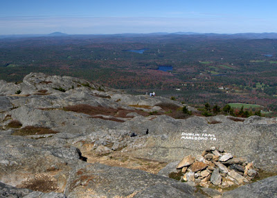 |
End of the M-M Trail and the beginning of the Monadnock-Sunapee Trail!
Mt. Sunapee is in the distance. |
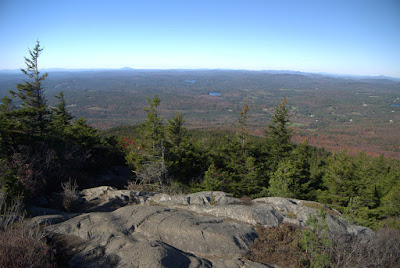
The screaming teens had thankfully left and the dozen or so people up there were just quietly soaking in the view. Gorgeous.
 |
| Gap Mtn and Little Monadnock look kind of flat from up here |
And cold. The high at the base was supposed to be in the 50's and it was around noon, so maybe it was in the 40's there, but with a good wind. My shorts and a tee shirt were quickly augmented by several additional layers. They say to expect the temperature to be 10 or 15° cooler at the top, plus a wind chill. That sounds about right.
 |
| Exploring the top |
My husband was still heading up the Dublin Trail with sandwiches, having stopped at the visitor center on his way over and starting his hike almost an hour after I did. So I walked around the top taking pictures for an hour or so. I never got bored.
 |
| One of several tiny puddles hosting Tussock Cottongrass |
Thoreau was right when he said, "
The great charm is not to look off from a height but to walk over this novel and wonderful rocky surface." The top of Monadnock is so high relative to the land below that everything in the distance seemed flattened and faded, like looking out the window of an airplane. Even the fall colors were muted. The effect is an amazing backdrop to that rocky surface, though.
 |
| Mt. Sunapee off in the distance |
Eventually my husband joined me and we sat facing Mt. Sunapee off to the north while we ate our sandwiches. I started getting cold. I had more layers in my pack but didn't feel like putting them on, so I started down the Dublin Trail very slowly to get out of the wind while my husband proceeded to the very top to check out the panoramic view.
 |
| Dublin Trail is also the beginning of the Monadnock-Sunapee Greenway |
So. The M-M Trail was done and I was starting a new trail and a new adventure! I wasn't sure if I was ever going to hike the rest of the Monadnock-Sunapee Greenway, but I could. Why not? Dublin Trail is also called the Old Farmer's Path and was the first of many trails built to the summit.
 |
| Typical sloping rock for much of the Dublin Trail. |
The Dublin Trail was not as steep as the White Arrow Trail, thank goodness. But it was wetter, and there were places where we had to either walk through water or carefully step on the dry spots to keep our soles dry. Wet boots can slip on that rock pretty easily, so we were cautious going down. It seemed to take forever, but there were spectacular views for much of it. There would be a flat stretch for 50 feet, and then another moderately steep section of rock to pick our way down. Over and over almost all the way to the bottom.
 |
Short flat stretches between rocky slides
|
There were a number of spots where we would get on our butts and slide and at one point a big hole ripped open in the back pocket of my cheap Cabela's hiking shorts where I had stuck my camera lens cap.
 |
| Much of the Dublin Trail was like this. |
But eventually the rocky outcrops finally ended and we were able to stroll down to the parking lot on Old Troy Road. It was getting late and the sun was low. I joked that Mt. Monadnock was the old person's Mountain Washington, which got a laugh. We had done Mt. Washington 25 years ago when we were both a lot younger and thinner and didn't have various maladies of the knees and ankles and feet. Although the climb up Washington is about twice as high as Mt. Monadnock, I think the effort and time we spent climbing Washington in our prime was about the same as our older selves climbing Monadnock. But hey, we did it.
 |
| It's getting late. A full day of hiking! |
We got to the parking lot at 5:15 pm. Almost 8 hours on the mountain. The parking lot was nearly empty and we had only passed a few people on the Dublin Trail.
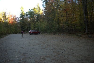 |
| A very empty parking lot |
So now what? Is the story over. No! The Monadnock-Sunapee Greenway has just begun. Two miles down and 46 more to go!


