Thursday, September 26, 2019

NH Cohos Trail: Fourth Connecticut Lake and Canadian Border

Starting out by headlamp
After seven years of sporadic section hiking up from Long Island Sound, today was the day I would finally reach the Canadian border and take a spin around the source of the Connecticut River. And the forecast was terrible. Showers in the morning and steady rain in the afternoon.  It was pitch dark when I headed down Sophie's Lane, trying to cover some ground before the rains hit. The Milky Way had stretched across the sky above my tent, so the clouds hadn't moved in yet, which was encouraging.

Sophie's Lane at dawn
The Cohos follows Sophies Lane, an old road and snowmobile trail, all the way to the border, so it was very easy going, even by headlamp. I kept my eye out for the eye-shine of moose or deer but didn't see anything.
Sophie's Lane. No rain yet.
It was six miles to the border, much of it on gravel. As the sky lightened and the sun rose, the colorful leaves and dark green spires of spruce and balsam were revealed. Those last few miles were bittersweet. I was eager to get reach my goal but also sad the journey was about to end.

Willow Midge Galls that look like Rhododendron flower buds
Eventually the gravel part ended and the lane continued on as a rough and often muddy snowmobile trail, and my pace slowed as I dodged the worst of the mud.

Sophie's Lane now just a rough snowmobile trail
Still no rain when I reach the Third Connecticut Lake. Another day, another Connecticut Lake. This one was originally called St. Sophia and is 100 feet deep.

Third Connecticut Lake
After exploring the Third Lake, it wasn't very far to the Canadian border. There was a funny moment where I passed a sign demanding that people PROCEED SLOWLY, and I reflexively started walking more slowly. The sign is, of course, for snowmobilers.

Getting close!
And there it was! The trail came out beside the U.S. border station, a rather cold and intimidating complex surrounded by chain link fencing, and took a sharp turn at a trail register and a sign for the Nature Conservancy's Fourth Connecticut Lake Trail.

Border facility and Nature Conservancy traihead
The Cohos follows this lollipop-loop trail up the hill right through the border clearing. It was pretty overgrown down at the bottom, and the tall vegetation was soaked, so I stopped to put on my rain pants prior to wading through it.

Following the border clearing
The trail starts out pretty steeply and there was one ledge that was a bit of a challenge to get up with a full pack on, but the view was worth it. I was not expecting that. And it still wasn't raining! Luck was with me.

Unexpectedly spectacular views going up the border hill
This is one of the most interesting trails I've ever been on. The treadway meanders through the border clearing, sometimes in the U.S. and sometimes in Canada. Back and forth, back and forth. There are lots of survey markers along the way marking the border, with placards on nearby trees calling out the often hidden survey monuments.

boundary marker
Once the border trail got through the thick vegetation and up the hill it was a breeze. The Verizon coverage map had suggested there might be a signal here, so I gave it a shot. And there was signal, though it was a roaming area. Amazingly, my husband had just texted that he was at the Brattleboro rest area at 8:55 am, only a few minutes ago. This was earlier than expected. I replied that I was almost to the Fourth Lake. He was still at the rest area and saw the text. Sometimes things just work out.

I don't speak French, so I'll go with 'no trespassing'
The Brattleboro rest area was about a four hour drive away, so I'd be getting picked up around 1:00 pm. The original pickup time was 2:30 pm, but my husband left early knowing I'd be waiting in the rain. Sweet. And he'd made it through I-91 rush hour traffic through Hartford and Springfield. So anyway, I had about four hours to kill. And it still wasn't raining. 

The trail then turned off the border clearing and headed southwest down towards the Fourth Connecticut Lake. Since I would be mostly just hanging out and killing time from this point on, I used the occasion to getting into some warmer layers and full rain gear.

First Connecticut Lake
And there it was, the source of the Connecticut River. A far cry from Long Island Sound, where it empties out. It was so peaceful. Not a soul was out there.

First Connecticut Lake
I somehow managed to spend a couple hours slowly circling the lake and exploring the trail. The trail was quite full of roots and there were a number of low areas with bog bridges and moose tracks.  Mostly I remember the thick blanket of vivid green moss and creeping snowberry carpeting the ground under the spruce and fir.

The lake is surrounded by a carpet of moss and Creeping Snowberry
There were several small streamlets flowing into the pond, but only one flowing out: The Connecticut River. It was barely flowing at all. I tried filling up my water bottle, but honestly the water looked pretty stagnate and I dumped it back out. I got water from one of the inlets instead.

The Connecticut River!
Somewhere earlier in this journey I'd seen white berries that I later identified as Creeping Snowberry. It may have been up on Mt. Lafayette. After reading that you could eat them and they're minty, I had regretted not getting a chance to taste them. And here they were once again, so I popped one in my mouth and indeed, they are minty. I just had one and left the rest. Leave the berries to the animals.
Creeping Snowberry - Minty!
Eventually I started back down towards the border station, going as slow as possible. Instead of the predicted rain, the sun came out and now I was sweating into my layers.

Heading back down the border clearing
Ah, but it was glorious. The official end of the Cohos is a tiny fenced area guarding a pair of monuments topped by the Canadian and U.S. flags. And the sun was out. What a perfect ending. It was noon and the predicted morning showers never happened. What a moment.

The end of the line
So now it was just waiting for my ride. I got confused about where I was supposed to wait. There was a little gravel area next to the fenced monuments that looked like a parking area, so I thought that was the parking area for the Fourth Connecticut Lake Trail, but I wasn't sure. I thought of trying to ask someone inside, but I couldn't tell how to approach the border fortress. I thought about walking around it on the lawn but wasn't sure if that was allowed. So I just stayed where I was, sat down, and opened up the Kindle app on my phone to read a book. I was there for maybe half an hour when a guy from the U.S. border complex came out and told me to move. Actually, he first asked if I was OK, and if I was American or Canadian, and when I said I was American he took my word for it and directed me to walk on the lawn around the fenced facility to the designated parking area. Never asked to see my passport, which I'd kept handy just in case.

Waiting in the wrong location for my ride. 
That made a lot more sense. The correct parking area is well signed for the Nature Conservancy Trail and a second sign directs hikers over the lawn to where I had been sitting, but none of that can be seen from the back side.

Meanwhile the sky had darkened and a cold wind had risen. It was getting really chilly. And then the promised rain finally hit. A cold, steady rain. That's OK. It held off in the morning so I couldn't complain.  It got cold though, and the rain was pretty heavy, so eventually I started walking down Route 3 just to warm up. Happily, the misery was short-lived. My husband pulled up shortly and I jumped into a warm, dry car. And with that, we set off to retrieve my car at Dixville Notch and explore Pittsburg.

Metallak commemoration on the way back to Dixville Notch


Wednesday, September 25, 2019

NH Cohos Trail: Tillotson Hut to Deer Mountain Campground

Up early to find moose.
This was the last full day of hiking before reaching the Canadian border and if I was going to see a moose it would be today in Moose Alley. The first sign of moose while heading north along the NET-Cohos route had been in Massachusetts in the Quabbin Reservoir area, and then there wasn't much heading north until the base of Mt. Sunapee in New Hampshire, where moose seem to own the trail and I'm pretty sure I heard one trotting and grunting down the trail past my tent that night. There were occasional signs of moose heading north from there until the Kilkenny, where moose seem to be everywhere. I'd probably seen thousands of moose tracks since the Kilkenny. But I wanted to see an actual moose while hiking in New England.

So today was the day and I set out early enough that I needed a headlamp at first even though it was already 6:30 am.  It had rained overnight and there were dark clouds and drippy trees. Prime moose habitat was straight ahead on the other side of Route 3, a five minute walk from the hut. The moose hunt had begun. 


MOOSE!!!
All the conditions were good. I was walking into the wind, it was very early, cool and wet. I tried to be as quiet as possible, setting aside the trekking poles and creeping up the trail slowly while scanning the surroundings like a hunter. I stopped to remove my rain pants, which were too noisy.  About half an hour after crossing Route 3, I came around a curve and suddenly there was big bull moose down on his belly thirty feet from the trail. He lurched his considerable mass up to his feet, then just stood there looking at me. WOW. Just WOW. He then turned and began to walk away, very slowly at first, and somehow not making any sound. And just like that, he was gone. Wow.

Bog bridge
And with my successful moose sighting, I scampered on down the trail to the 800-ft bog bridge for which this part of the trail is named (Bog Bridge Trail). What a great day! Last full day on the NET-Cohos and I saw a moose. How perfect is that?

Bunchberry in moss
The bridge was super slick and treacherous and even though I was taking cautious baby steps, I still slipped and fell on a section that had broken and tilted slightly. My trekking pole jammed deep into the bog and came out decidedly bent. It's still bent. Chicken wire would be helpful here. But it didn't matter, because I saw a moose.

Joseph is 92 and caught a 4 lb salmon in the CT River that morning
The trail crossed Magalloway Road near a bridge over the Connecticut River, and there I met Joseph waiting for his son, who was nearby fishing in First Connecticut Lake. Joseph said he was 92 and had caught a four pound salmon just that morning there in the Connecticut River. Catch and release. An SUV with a couple of sightseers stopped in the middle of the bridge to chat, which somehow didn't seem odd. They were driving around, thought maybe they'd see a moose. Joseph recommended they keep driving up the hill to a lookout on the hill with great views.

Still happy about seeing a moose
Moose Alley Trail was the next part of the Cohos and it lived up to its name. I didn't see another moose, but I did hear one. I was signing into the trail register when I heard what I thought at first was maybe voices off in the distance until I walked over the rise for a better listen. The sound was drifting up the hill from the low boggy area down below and no, that wasn't a person, it was a moose. What a weird sound. Kind of a sporadic moaning. I hung out for a good twenty minutes just listening.

Heard a moose calling while signing in
This was, of course, great moose habitat, and that included vast areas that had been logged, full of brush and young trees on which the moose could nibble. Must be tough keeping these sections of the trail clear, but someone was doing a great job.

This feels like a Christmas Tree farm

Lots of recent tree clearing
After that excitement, the Cohos joined the Falls in the River Trail and started following the banks of the Connecticut River, which was roaring down below. This day just kept getting better.

The Cohos runs above the roaring Connecticut River
The falls were gorgeous, especially with the changing leaves. Great place to hang out and take a break. This was an obvious day-hike destination.

Falls on the Connecticut River

Falls on the Connecticut River
Further upriver, the river calmed a bit but was still flowing strong. The trail stayed close to the river for a long ways, with some overlooks.

Connecticut River
And another treat: Second Connecticut Lake. The trail popped out at the dam on Route 3. How will I ever get to my destination if I have to keep stopping to enjoy these beautiful sites?

Another day, another Connecticut Lake
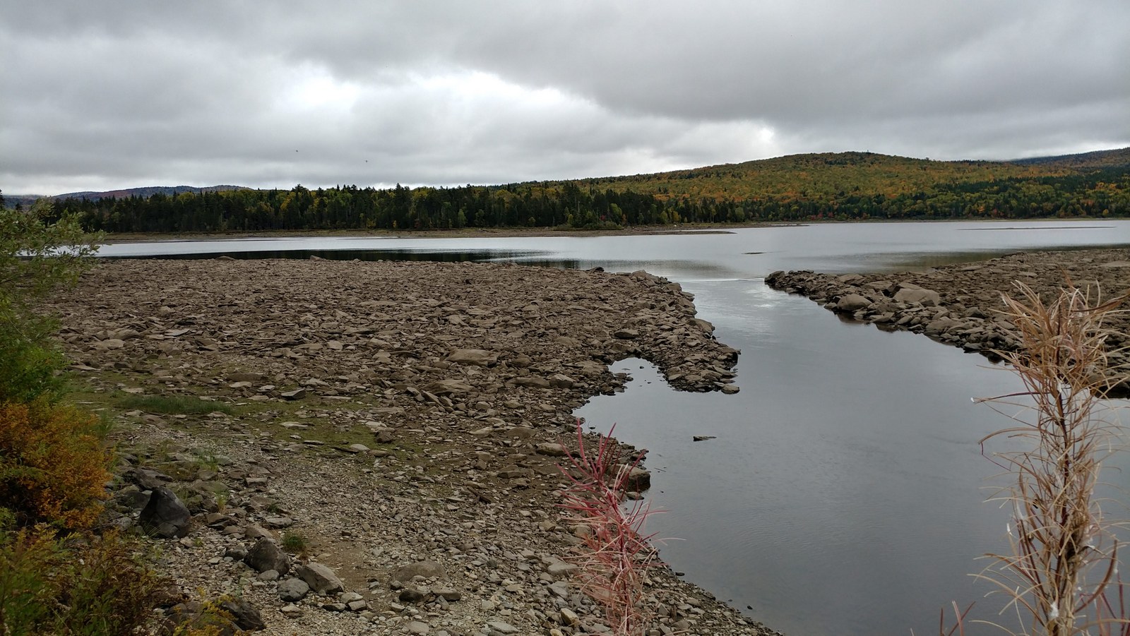
The water level in the reservoir was low, so I was able to walk way out to the outlet of sort, which is the Connecticut River. This is before the dam, so when the water is higher it must be invisible, under the reservoir. And the channel must be really deep, because it didn't seem big enough for all that water that was roaring down below the dam.

Second Connecticut Lake outlet (Connecticut River)
What was the purpose of the dam? Didn't seem to be hydropower. The Internet says the Connecticut Lakes were created back in the 1800s for logging drives. Imagine this lake full of logs in the spring.

Wild Raisin at the 2nd Connecticut Lake dam
After the dam, the Cohos closely paralleled Route 3 for a spell (there was very little traffic) and then crossed for the last time and became Lower, Middle, and finally Upper Black Cat Trails. What's the story with the black cat?

Fern Moss next to a Christmas Fern
Though not as exciting as the first part of the day, the Black Cat sections were enjoyable and easy enough to follow. The miles melted away.

U.S. Route 3 is strangely deserted this far north.
At one point the trail cross a ribbon of dead limbs going down the hill unlike anything I'd ever seen. It looked like there had been an avalanche of dead trees. I decided it must have been a logging road stabilized with slash. That's the only thing I can figure. The slash was several feet deep.

A river of logging slash? 
Lower Black Cat had the last of the cell phone coverage until some possible coverage at the top of the Fourth Lake, so I had been checking the weather forecast. It was not good. The next day would have morning showers switching to steady rain in the afternoon. It was a real disappointment for the last day of the hike when I'd finally reach the Canadian border, and I wouldn't be able to take any photos with my touch-screen phone in the rain. I decided I'd start hiking as early as possible and try to get to the Fourth Lake before the heavy rains hit. My husband was planning to pick me up at 2:30 pm after a six or seven hour drive from Connecticut, but I needed to get out earlier and would just have to wait in the rain. I texted my intentions and said that if was raining really hard, I'd probably walk down Route 3 back to the Deer Mountain Campground and try to take shelter there. And then I slipped into the no-phone zone.

Beaver stump
Approaching the campground, the Cohos came to the junction with Sophie's Lane and there was a big map kiosk. I studied the map and learned that Sophie's Lane started out as a gravel road and was a snowmobile route all the way to the border. So I could start walking this in the dark and it would go fast. Good to know.

Junction with Sophie's Lane
To get to the Deer Mountain Campground, you turn off the Cohos a short ways, coming out onto Route 3 once again, and crossing the shrinking Connecticut River.

The Connecticut River, getting smaller
Route 3 was ridiculously quiet. Five minutes could go by without a single car passing. It was weird.


Deer Mountain Campground entrance, Route 3
The campground is run by the state and for some reason I thought it would be like the campground at Coleman State Park, with a bathhouse and showers. Nope. There are outhouses. For water, there was a spring out by Route 3, and when I turned the faucet, a trickle of water came out, but after getting half a liter, the water stopped. I finally just got water out of the river.
Campground spring barely trickled
Not many people were in the campground on a Thursday night. I selected a private site (#26) on the shore of the Connecticut River, which was a narrow, quiet stream at this point. After setting up on the big wooden platform in sporadic showers (next time I must buy a complete free-standing tent), I set out to explore.

Tent platform alongside the Connecticut River
I took a trail to a reservoir labeled "Moose Falls Flowage" on the campground map. Tent site #28 was located there, but was taken. What a tent site. They had the pond all to themselves.

They have one amazing tent site at the far north end of the pond
Sophies Lane, and the Cohos Trail, were on the other side of the dam, but I wasn't going to see this the next morning in the dark.

Moose Falls Flowage (Connecticut River)
And that was it for the day. Early to bed, the next morning would be an early one. Sadly, some camper came back obviously very drunk and started belting out songs as loud as he could possibly sing. It went on and on. I put in my ear plugs and donned my sleep phones, turned on the sound of a fan, and the drunk guy was history.

Last night ever on the NET-Cohos

Tuesday, September 24, 2019

NH Cohos Trail: Happy Corner to Tillotson Hut

Took a wrong turn... but the view was great!
Day four of my final trip was a day of wrong turns. I took more wrong turns and had more trouble finding the trail in this section than the entire rest of the trail combined, by far. I started well enough from the campground by finding a shortcut out to Danforth Road rather than walking all the way down the hill and then back up again. So far so good. But soon there was a road veering off to the right, and intuitively that felt like the correct way to go. But before going that way, I checked the trail map, which indicated the trail followed Danforth Road. The street sign said the right option was Kingfield Road, so I passed it by and kept going straight up and up and up the hill. At the top, I stopped to enjoy the view and check the gps track on Maps.ME. Good thing I did. I was WAY off course. It had to be that road junction where I went wrong.


Screenshot: Not where I thought I was
So I went back down, and yes, that street sign definitely said "Kingfield Road" and it was oriented parallel with what the trail map said was Danforth Road. Huh. Unless the street sign was hit and twisted by a car? Or maybe they mark their streets differently here? And Kingfield Road was the name of the road on the left, the one I took by mistake, so why did Maps.ME call it Coville Road? I continued on to the next road junction, which a street sign said was Coville Road. What the what? Later I checked Google Maps, and their road names matched the street signs, but Maps.ME was way wrong. At any rate, this would be a good road junction to throw up a blaze, since the street sign is confusing and at least one map application is wildly inaccurate.

Confusing road sign
The rest of the way up to the summit of Prospect Mountain was OK and there was a great view of First Connecticut Lake down below. Another day, another lake. Nice.

First Connecticut Lake from Prospect Mountain
It was spotty showers again for the day, after a rain the night before. Annoying in some respects, and a bit depressing, but fall colors can be richer with cloud cover. And the low clouds were moody over the lake. At the overlook were some Lady's Tresses were in bloom. These are orchids and I wouldn't expect to see something like that at the end of September with the changing leaves.

Ladies Tresses at the overlook
The trail between Prospect Mountain and Covell Mountain is called Ramblewood Link Trail, and that was a real challenge to follow. The woods were pretty open, more like Connecticut, and the trail seemed to be trying to make its way around private lands through some terrain that was pretty lumpy at times. The trail was blazed throughout, but there were several spots where the trail suddenly turned and there was just nothing indicating which way you should go. I often referred to the gps track on my phone, but that didn't always help. 

Go left then right? Long curve to the right? Beware of boomerang?
There doesn't seem to be a trail-wide standard for blazing, so the turn indicators are inconsistent. I found this to be true of the Monadnock-Sunapee Greenway as well. They do not use the offset double blazes I'm so used to in Connecticut on the Blue-Blazed system. Those can be admittedly confusing when you first see them, but after a couple turns it's easy to catch on, and every turn of the 800-mile system is marked in this way. Trail Managers in Connecticut have to take an orientation class and are taught how to do the blazes so everything is consistent. Here, it seems like blazers are free to use whatever they feel makes sense as long as it's the right color. A lot of turn blazes along the Cohos are like an upside down "L", and this is pretty intuitive and works for me. And most of the terrain is super thick, so it's hard to meander off the path in most areas.

This part is easy
But when the terrain gets really open and there are lots of twists and turns, it's very helpful to let hikers know which way the turn is, and how far. There were double blazes with no turns, double blazes with turns way way beyond the double blaze, sharp turns with no double blazes, and often no blazes immediately after the turns. The latter tended to be the most difficult. The trail would just disappear.

Turn which way? None of these markings are helping. 
One spot in particular I floundered about for a good 15 minutes. There were multiple marking indicating a turn. Where? I looked and looked. The markings did not indicate if it was a left turn or right turn, or if the turn was right there or 100 yards further. One of the markings was actually two horizontal lines, which meant nothing to me (in Connecticut it means "end of trail"). There were many possible treadways that fizzled. I kept trying to follow various options, including several route straight ahead that went through heavy vegetation that had been trampled (hikers? moose?). I finally found the correct way was a hard right. There was no tread in that direction and no blazes visible from the double blaze. In retrospect, the two horizontal blazes might have meant "turn exactly here" but I've never seen markings used like that.

Covell Mountain summit
But after slogging through lots of such mystery turns, I eventually made it to the top of Covell Mountain, where it started to rain.

Giant rootball/rain shelter
An enormous rootball offer great shelter from the sprinkles as well as a view across the lake. Great time to start in on that local fudge! I normally do not touch fudge, but while backpacking it's OK.

Fudge reward

View from Covell Mtn. 
The trail was thankfully easier to follow north of Covell Mountain and there was no rush. This section was only eight miles, and even with the wrong turns and lazy late start, there was plenty of time to make it to Tillotson Hut.

"Conversation Rock"
One thing they do that I like is post a few random routered signs for things that make you go 'huh.' One such place was "Conversation Rock." You just know there is a story there. And it will be used as a reference point when doing trail work.

Tree Lungwort
One interest find along the trail was a patch of Tree Lungwort, also known as Lung Moss, Lung Lichen, and Oak Lungs. It's reportedly in decline around the world due to acid rain and forestry practices and is associated with old growth forests. Because the leaves resemble lung tissue, this lichen was used for lung diseases such as asthma back in the day when that sort of thing made sense. Moose and deer eat this lichen.


For Sale at Round Pond
The Cohos came out onto a road serving camps along the shores of Round Pond, and I passed a thru-hiker headed southbound. She said she had started the day before, so she was making great time, probably leap-frogging the campsites. Twenty miles a day instead of ten. Ahh, bless the young and fit.

More trail confusion at Round Pond Brook
I had more trail confusion for a few minutes when I followed the blazes to a stream. The blazes just stopped but I kept trying to figure out how I was supposed to cross the stream and continue. Eventually I studied the map, realized the trail did not crossed the stream, and figured out that it was just a spur to the falls not the main trail. I'm used to spurs being blazed differently than the main trail. In Connecticut, this would be yellow + white or yellow+ red, or some other color or shape.

Heading into Mooseland
As the trail got closer to Tillotson Hut, the land dropped into some low areas that were just full of moose tracks. I really wanted to see a moose while hiking. I've seen a couple while hiking at Yellowstone and the Grant Teton National Parks, but that's a step above seeing them at a zoo. I wanted to see one while hiking in New England.

Bear claw marks
I also saw some bear claw marks on a tree. I don't need to see a bear while hiking. I checked that off the list earlier this year in Connecticut. A mama bear and her cubs walking down the trail right at me.

Garter Snake hiding in the leaves
Tillotson Hut was beautiful, like so many other huts along the Cohos. I was there before 2:00 pm, stepping over a Garter Snake in the access trail. Part of me wanted to keep going, but not for another nine miles. I'd have to stay here for the night.


Tillotson Hut
The craftsmanship on these things is just amazing. Look at how the logs are notched to fit together at the ends. There's also a sweet-smelling privy and a water source nearby.

Craftsmanship!
I dipped a bottle into the shallow stream and a salamander darted away. Caddisfly larvae crawled around the bottom, a marker of great water quality.

Red Backed Salamander 
My tent was pretty wet from rain the night before, so I was able to start drying that out by hanging it out under the shelter overhangs. The temperature was dropping, a wind was blowing into the shelter, and it promised to be a much colder night. I wanted to be in my tent, which can be significantly  warmer than outside, surprisingly so. As darkness approached and it seemed no one else was coming to share the shelter, I set the tent up inside the shelter.


Home Sweet Home for the night

I signed the guest book after dark. I was just finishing up when a pack of coyotes nearby started yipping. Oh they do put chills down your spine. I was happy to crawl into the tent and zip it up.