Tuesday, July 31, 2012

Rattlesnake Mountain, Farmington


Slug weather.  
Welcome to the back side of summer and in Connecticut you know what that means: Slugs. There they are, leaving that gooey trail of slime everywhere they go. This was the trip I set my logbook down to stamp in, and after getting a nice firm impression of a beautiful hand-carved stamp in my logbook, I picked it up and discovered a smashed slug on the cover.  Ewe!!

Another gauge of the humidity: I pulled my camera out of my backpack and took a bunch of pictures only to discover the lens had completely fogged over and my pictures were more or less blank.

Goldenrod
So it's not my favorite time of year for hiking, and usually I don't bother hiking in summer, but I've got it in my head that maybe I can box the entire Connecticut section of the NET by the end of the year. One full year to hike the Connecticut NET, reflecting all seasons, albeit without snow.  I just happened to start this journey in January, assuming it would snow soon and that would be the end of my letterboxing for a while, but fate handed out a freakishly warm winter and I made great progress up the trail week after week. I thought it would take me two years to get to Farmington and yet it's only July. Keep in mind I'm not simply hiking the NET, but trying to find all the letterboxes along the NET as well as along all the connecting trails. Many of the parks the NET passes through I've visited repeatedly. I was up on Chauncey Peak four times.

Christmas Fern, an evergreen 
So I picked the coolest day of the week and hit the trail.  I pulled off Route 6 next to private road plastered with no parking signs (the road is said to lead to the Channel 30 broadcast towers on Rattlesnake Mountain) and headed south.  The goldenrod was in full bloom, and to me that means late summer and the promise of approaching fall.  Berries were ripening and the fridge is full of garden produce (summer squash, anyone?).Almost immediately the trail passes a fork with a sign that indicates a parking area further west along Route 6, so clearly people must go hiking here quite a bit. This was a Monday, so I didn't expect to see anyone all day, although I did pass a few people.

View north along the Metacomet Ridge, Hueblin Tower in the distance
Very quickly there's a view looking north at what must be my first glimpse of Hueblin Tower up Talcott Mountain State Park in Simsbury, about ten miles away as the crow flies. Neat. I was there a few years ago.

The first part of the trail went through very open country with only scatter trees where it must be a nightmare to keep the trail clear from overgrowth, so I give a round of applause to the volunteer Trail Manager of this section.

A very old Chestnut Tree, continually reborn
Eventually the trail enters the forest as it climbs Rattlesnake Mountain.  The photo above is a Chestnut Tree, shown in it's typical modern form.  This tree is probably hundreds of years old and once may have been several feet in diameter, but the portion above ground was repeatedly killed off by the Chestnut Blight. Typically, the tree will resprout and thrive until it is a few inches in diameter before it is struck by the blight again and dies back, only to resprout. You can see the old decaying sapling next to the sprouts.

Polypody: the cute little fern that grows on boulders

Possible spaceship or rocket launcher


The trail passes the Channel 30 towers and a couple rocky places with mostly obstructed views (wrong season) before arriving at Will Warren's Den, marked with a plaque.
There was also an interpretive sign, which was good because I had no idea who Will Warren was. According to the sign, Mr. Warren was an outcast from the nearby village who was accused of various crimes such as stealing sheep, and at one point supposedly hid in the small cave there while the villagers were hunting him down. My terrier immediately plunged deep into the cave, because that's what terriers do, and came out all relaxed, which means there are absolutely no mammals living in that cave at the moment because she would have told me if there were. 

Biscuit certifies Will Warren's Den as animal-free

Will Warren's living room?
There's quite the jumble of boulders there, and a nice overhang around the corner from the cave looks like it would have been a great place to set up camp. The trail climbs up above the boulders and before you know it comes out onto one of those Metacomet Ridge vistas.  


Looking south towards the Tilcon Quarry and West Peak
This vista messed with me, though, because I'm so used to looking West at a vista, and this one was looking South at a cliff running East-West. Wha?  Not where I was expecting to be looking.   There's West Peak once again in the distance, with the Tilcon Quarry in the middle distance.

In this view you can see "the Pinnacle" -- that cliff at the lower right
And then there was the rock I was headed for, "the Pinnacle", about where I left off last time.  Zooming in with the camera lens I could see the railings and bench atop the rock. Ha! So down the mountain we go, steeper than expected, along a narrow tread barely benched into a scree slope along the base of some cliffs. The reward is something I've never seen before: The trail goes right through a cave (or what in Connecticut qualifies as a cave), formed by a couple of big boulders.

The trail goes right through this "cave"
In the cave is an inscription that looks pretty legitimate to me that reads "J.A. McCo 1882 Oct.1."  I wasn't able to find out anything about this.  Opposite this historic inscription was a sticker that said simply, "I love Hooters."  Times have changed. 

Engraving in the cave.
Joe Pye Weed
Wild Ginger


Old quarry, looking north

After continuing on the steep descent the trail crosses some powerlines, heads back up a bit, and a short detour leads to a northern overlook of an old quarry.  The line of boulders keeps four-wheelers from plunging off the steep face of the cliff. 


False Solomon's Seal, berries ripening
After that the trail was pretty uneventful, but longer than expected, heading gradually uphill towards the Pinnacle. Are we there yet? And finally yes, I rounded a corner and there was a section of trail I had been on before. Time to turn around and head back to the car. 

Old fashion trail blaze

Saturday, July 21, 2012

The Pinnacle and Hospital Rock

"Why is that human whistling?"
Yup, the deer have been eating.
What a great hike!  In addition to breezy, cool, dry air in July, I found some cactus as well as a piece of early American history in the form of "Hospital Rock."  But I've jumped ahead. The hike started with a ramble back up the New Britain section of the trail for about a mile so I could hide a letterbox, just south of I-84 and near the Tilcon Quarry. Right off the bat I got to have a nice conversation with a doe, who was polite enough to wait around while I leashed my dog and dug my camera out of the bottom of my pack. She clearly knew that I was right there but just kept chomping away on the vegetation until I whistled.

Chicory
I hid the letterbox for New Britain near a certain leaning birch tree with bark that's smoother on top and headed back to the car on Esther Street.  If I was a purist I would walk all the road parts, but I'm not, so I follow the blue-blazed route along the roadway in the comfort of my car across I-84 and parked at 440 New Britain Ave in the parking lot for New Alliance Health (thank you, thank you, thank you, for not putting up some signs telling me not to park there).  Hopped across the street and there was the trail and an old railroad track.

This time of year there are a ton of wildflowers growing along the roadways.  Almost none of them are native for the simple reason that the soil conditions along our roads is completely different than any natural soil ever found in New England. It's highly compacted and the chronic salt usage has changed the soil chemistry. For one thing, the soil is very alkaline, while our natural soil is very acidic. Most of the roadside plants originated in far away lands with barren, alkaline soil, atop chalk cliffs, for example, and are well adapted to these conditions.

Queen Anne's Lace 
There is a profusion of Queen Anne's Lace and Wild Chicory all along Connecticut's roads right now. Chances are, if you see white flowers they are Queen Anne's Lace, and I guarantee that if the flowers are blue, they are Chicory.  Queen Anne's Lace is also known as Wild Carrot because it is the ancestor of the domestic carrot. The root looks pretty much like a carrot but you really can't eat it because it's too fibrous. It's noted for how the bloom curls up into a 'bird's nest' when it's done flowering.


Everlasting Pea
Chicory is special, too. The root has often been ground and added or substituted for coffee.  Check the ingredients for some of Celestial Seasoning's herbal teas, and you'll see "roasted chickory."  I've never tried it because the only place it grows around here is along roadways, which are invariably contaminated with heavy metals, and you don't want to eat anything gathered there.

The most dramatic flower was Everlasting Pea, which actually had peas. Again, not a native of North America. That one is not so common. It was growing along the railroad tracks rather than along the nearby roadway.


Prickly Pear on the cliffs

I had a lot more fun later on when I headed up the cliffs and found some Prickly Pear cactus.  Finally! I've seen Prickly Pear, a plant native to Connecticut (YES this is true) growing in sand in Stratford and Milford, but never along the trap rock cliffs where it is said to grow. And here it is.  Looks like it bloomed, too. Sorry I missed that, the flowers are beautiful. PS never touch the cactus.  There are invisible thorns. You will need a magnifying glass and tweezers to get them out. 


Tilcon Quarry and I-84

The New Britain section of the trail that I was on earlier in the day ascends the ridge just to the  east side of Tilcon Quarry (to the left in the photo).  But this was the first time I got to actually see the quarry.


It's a mostly a gradual ascent heading up towards Pinnacle Rock, with the occasional view like this one. Unfortunately there was an ATV trail that also leads to this spot, and so there was a fire ring a pile of litter. The only time I see litter along this trail is where there is an ATV path. 

Hot tub for dogs, with a view
There's a lot of open ledge as the trail finally approaches the Pinnacle, with Rattlesnake Mountain and some kind of radio tower coming into view to the north. All very dramatic.

Rattlesnake Mountain coming into view 

The Pinnacle

Railings!  There are railings up at the top! And a little bench. Ha. And people were ironically using the railings to attach their rock climbing gear to. That's funny.

Hartford, closer and now more to the northeast than before


I didn't go much further along the NET than that, but decided to explore some of the unmarked side trails. I was keeping an eye out for the elusive "Hospital Rock," which is said to be nearly impossible to find without directions. Reasonable historians don't want the general public to know where it is, because you just know some idiots will deface it. So it's pretty much a secret.  All  knew was that the rock is nondescript, in the woods, and somewhere in the area.  

On the rock are many carvings from the 1790's of young people's names that were under quarantine for small pox inoculations. Back in the good old days, they would take the pus from a small pox sore and rub it into a scratch. With luck, you would get mildly ill for a bit then be immune to small pox for the rest of your life, which was a good thing because it was very deadly and horribly scarred many survivors.  After the inoculation, people were contagious for a few weeks, so a small hospital was set up in a remote area to house the people getting the inoculation. 

Amazingly, I found it. I will do my part to keep the secret and won't tell you how I found it, other than that the fact I used  my geeky geology background and a dose of intuition. But I'll share some photos. Bear in mind, these names were carved into the rock the same decade that our Bill of Rights were passed. You might say these young people were of the very first generation of U.S. citizens. In the bottom photo is the word "liberty,"  and it's circled. 


Wednesday, July 11, 2012

Welcome to Southington. No Parking Allowed.

Blue Cohosh at the cliff bottom
I said I would return to the back end of Ragged Mountain since I loved that section of trail so much, so I did.  Last time we did a great big loop and parked on Andrew Street here, at a small pull-off next to a big apple orchard.  I remember saying it looked like the spot where people park to steal apples. My son work in a local orchard a few seasons ago and came home with stories of people filling bags of apples, hiding the bags on the edge of the orchard next to a quiet road, then coming back later in their car to snag the bags without paying. But there weren't any signs saying you couldn't park and it's basically the shoulder (ie City property), so we left the car there and had no problems.

One reason we had been doing a big loop is that there is no parking allowed on Carey Street, which is the next road crossing to the south. The rock climbers, who own the cliff face of Ragged Mountain, have a lot of parking issues because their property deed does not allow them to create a parking area on the property.  They have to park far away and walk in, and one of them had passed us walking down Carey Street.

This time around I wasn't doing a big loop and wanted to park as close as possible to the trailhead, which is at the intersection of Andrews Street and Long Bottom Road, located here.   I arrived at the intersection and looked about for somewhere to park.  The big triangular island seemed like a natural spot and I'll pulled in there, but then noticed some tacky 'no trespassing' signs tacked up on the telephone poles there. I almost missed the signs complete. That didn't seem right, and my hunch was, and still is, that a neighbor placed the signs there without permission because they don't like seeing cars parked there. Unsure, I tried to pull up next to the trail, but the terrain was a big steep for my tiny car. After circling around about three times I finally pulled off the shoulder next to the orchard, being careful not to block any traffic (see picture below). Seem reasonable?  The pull-off where we parked last time about about 1000 feet down the road, and was still next to the orchard, so what's the difference, right?


Spirea at the lookout
So off I went, again enjoying this part of the NET.  I scrambled up the beautiful and intimidating cliff, and at the top this time I took the short spur to the overlook. I really couldn't see the cliffs of Ragged Mountain like I hoped, but it was a great view, and I could see Hartford in the other direction as well.   I rambled on for a mile or so, fully enjoying the ridge top hike and view of the Shuttle Meadow Reservoir below.

I found a big beautiful Black Rat Snake sunning himself on the ledge in a crevice.  His body was totally exposed, but his head was jammed into the leaves, and he never even saw me. My silly dog never saw the snake, either, and actually stepped on him.  It didn't seem like a very good survival strategy. Eventually I got him to pay attention so I could get a photo of his face.
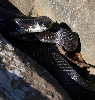
Well, hello there. 

And so I headed back down to the car where I found this note on my window:  


And my initial thoughts were along the lines of: First of all, I'm not even from this area, I have no idea what your orchard is called or where your store is located. Second of all, I'm parked on public property, and I'm not causing any type of hazard or blocking anyone, so shut up. Parking on the shoulder is LEGAL as long as you are not on someone's private property, not causing a hazard, and there aren't any 'no parking' signs.  I have the right to park legally without being harassed. Third, I'm parked at the trailhead for a National Scenic Trail and walking up a trail with my backpack and trekking poles in plain site, obviously not causing any vandalism, so spare me the rationale.

Back home, I looked up Southington's excellent online GIS system. The big traffic island is owned by the Town of Southington and really shouldn't be posted with cheesy 'no trespassing' signs. Someone should look into that. The guy who wrote the note telling me not to park on public property happens to live in the house overlooking that spot. I'm guessing he's the one that posted the public property as private. The location of the store where he says I can park is like a mile away or something absurd.  Why on earth would I park there?

Then I checked with the geocachers, because they know everything hiking related. There are a few geocache listings along that part of the trail and the people who listed the caches are telling geocachers to park about 1000 feet down the road, the same spot where we had previously parked, in the remote pull-off that looks like it's for people stealing apples.  There are a lot of online notes from geocachers who parked there and no one has had a problem. So apparently it's OK to park there where a person could steal apples in seclusion.  But not in plain sight of the orchard owner's house, where he can see you get out of your car with your nerdy hiking gear and head up the trail.  And there's your car parked there in full view, clearly visible from his house. Gosh, that must be disturbing to see that car parked there.  I've run into several people, usually elderly women, who run out and leave notes on the windshields of every car that parks in front of their house. Why? They just start to feel like the street belongs to them and they can tell people not to park there. And I guess they have nothing better to do.  Disturbingly, one of the geocachers mentioned that she parked in the "wrong spot" and got a $30 ticket. I wonder where she parked, and whether she got a ticket because she was disturbing someone's view.

Dear Town of Southington, PLEASE designate someplace for people to park. You have a historic National Scenic Trail that travels the entire length of your town, and you have not one single designated parking spot for this wonderful public amenity other than a lengthy access trail at Crescent Lake near the border. I've been hiking this trail all the way up from Guilford and never, until I hit Southington, did I run into this problem. 


Chinese Mystery Snail 
Enough of that, let's head over to Crescent Lake.  This was my first time walking along the shoreline (the NET runs along the ridgetop above).  There's a network of trails in there, green, orange, and red. I followed the green trail with a short diversion down to the pond to take a look. 


There were some really big snails, I've only seen them before at Black Rock State Park, called Chinese Mystery Snails. These invasive snails are used in the aquarium trade and may have been released when someone dumped their aquarium contents into the pond. Bad idea. 


Ducks and floating dead Mystery Snails on Crescent Lake
 There were also a lot of ducks. I mean a LOT of ducks. Duck eat, duck poo, and the algae gets super fertilized. Which explains why I didn't see anyone swimming or any signs about swimming. I then rambled on up the hill to the blue trail and an overlook of the pond. This may be the greenest pond I've ever seen! But maybe that's just because you don't usually get to view pond from above unless you're a pilot, I don't know. It's still a beautiful sight, I just don't think I'd want to swim in there!

Crescent Lake from the NET -- Very green!