Saturday, June 29, 2019

NH Appalachian Trail: Mount Mist

Cold War Redstone Missile in Warren
More Americana
This wasn't a very long hike, so let's start out with what is possibly the only missile on display in a public park. We passed it in Warren after spotting my car for some slackpacking. The missile is pretty big and hard to miss while passing through. This is where Routes 25 and 25C come together. Warren seemed like a nice little sleepy New England town, the type Stephen King likes to write about. After a joyous stop to consider this oddball piece of Americana, we continued up the road through heavy rain to where I had left off the day before. This is where the Appalachian Trail crosses 25C.

As we drove through the rain, I was pondering whether I should have hiked it the day before rather than saving this part of the trail for now. I had wanted something to do while my husband played a round of golf, but what the heck. As they say, there's no such thing as inclement weather, only improper dress, and I had rain gear. Also, it's called  Mount Mist. Rain seemed appropriate. The forecast was for scattered showers and thunderstorms, possibly severe.

Nice and easy.
It turned out to be great hiking weather for the end of June however. No more rain, and apparently it never rained very hard on the trail. This entire stretch of trail turned out to be a lot easier than the previous sections and it went fast with little effort.

The dramatic top of Mt. Mist
Mt. Mist didn't have much to it. It was a gradual uphill and a nondescript wooded top, where I could see someone had set up a tent the night before based on the dry rectangle on the ground. I set my pack down for a bit and a thru hiker came by and asked if I knew the weather forecast. I gave him the bad news. He was hoping to get over Mt. Moosilauke before taking a zero day. Potential severe storms would not be fun at the top of Moosilauke. We discussed the dangerous descent northbound on the Beaver Brook Trail, something I'd read about over the winter. I was able to open up the Guthook app, show him where the Beaver Brook Shelter was at the top of the descent, how many miles down the trail it was, and then we read some of the user comments to get a better idea of the site. I was glad to be of help.

He had no sooner left when another backpacker came up the trail. "Welcome to Mt. Mist!" I proclaimed. "Is this the top?" he replied and we had a good laugh before he asked if I'd seen his wife. "Red hair? Saw a moose yesterday run across the trail in front of her?" "That's the one. How far ahead is she?"  "Pretty far. Good luck." We had a nice chat. They were section hikers. Backpackers on the Appalachian Trail tend to be very friendly and chatty.

Mt. Mist overlook
There was only one overlook. Mt. Moosilauke was shrouded in clouds. I understand that is the normal state of affairs for that mountain.

Mt. Moosilauke in the clouds
It was a a quick and uneventful walk down Mt. Mist. It was so nice to be able to stretch my legs and just walk without having to think about the placement of each step. Just a nice woodland trail.

Amanita

Foam Flower. A great native planting for a shade garden.
The most interesting feature of this section of trail was the ford over Oliverian Brook, near Route 25, and my map had a note not to try and cross it if the water was high. Would the water be high? No idea. The last ford along my trek up from Long Island Sound was through the Westfield River in Westfield, Massachussetts, a much larger river that was in drought conditions as I passed through. This river turned out to be much smaller and no problem at all.


River Ford
What made the ford interesting were the massive stone steps on either side, obviously designed not to wash out during a flood. They were also a good spot to sit down and put your boots back on after wading through the water, which didn't even get up to my knees.

Steps down to the ford
There was about another mile of trail after that, gradually uphill towards, and suddenly I was at my car at the base of the Mt. Moosilauke on High Street. That was quick. It was only 1:00 or so and I was done hiking.

Lincoln Tourism
So I headed back to the B&B, took a shower, and waited for my husband to finish his 18 holes of golf. Normally we finish up about the same time, but this hike was so short I was done early. Eventually I drove up I-93 into Lincoln and checked out the White Mountains Visitor Center. They have a nice diorama of the White Mountains. I also stopped at the  Mountain Wanderer Book Store, which specializes in hiker/outdoor books.

Diorama of the White Mountains
In the meantime, my husband finished up his golf game (I hear the bugs were quite bad and he forgot bug spray), and had taken a shower. Great! We took a drive back to Plymouth and had dinner at the Last Chair, where I was able to enjoy another glass of 11th Regiment IPA. Nice!

Storm Clouds building over the Last Chair restaurant. 

Thursday, June 27, 2019

NH Appalachian Trail: Smarts Mtn to Cube Mtn and Ore Hill

Red Eft on bog bridge
Day 2 of this backpacking excursion begins at 4:15 am (!) on Smarts Mountain when the sky begins to brighten and I can't get back to sleep. I'm not a morning person, but I finally give up and get up and start breaking camp at 5:00 am.


Back up the fire tower
By 6:00 am I'm packed and back on the trail, stopping to check the view on the fire tower.


Wow.
There's a beautiful sea of fog down below. Mountain tops have become islands. Gorgeous.


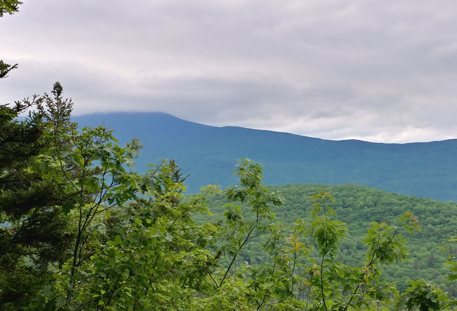
Cube Mountain (left) and Mt. Moosilauke on the horizon (right)
During the drama that was the never-ending lightening storm the previous night, a lot of rain was  dumped on the trail. I felt like the sky was trolling me for having to carry so much water up the hill. I bet the "weak spring" was flowing great, although I didn't look for it.


Regular Trail Mud
This was a day of mud. I have never hiked through so much mud in my life. I considered it good practice for what I hear is pretty common on the Cohos Trail further north. There was regular mud, which could be deeper than your boot in spots, who knows.

Moose Poop Mud
There was moose poop mud, which was pretty common for the first mile or two going down Smarts Mountain. Sadly, I did not see a moose. There was shallow mud and deep soupy mud, still mud, flowing mud. Mud with stepping stones and mud so deep it was a real struggle to find a way through. Mud with logs thrown in to step on.  Further down the mountain there was mud with firm sand underneath. That mud was my favorite. Easy to walk through.
Trail Turnpike
You're not supposed to try and walk around the sides of mudholes because that makes the trail tread wider over time, but it was hard to avoid it after the storm. The mud was so deep and there seemed no bottom to it. As the trail headed further down the mountain and there was more of a grade, there were a number of welcome trail improvements to help hikers over the worst parts and to direct water off of the trail.

Bog Bridge
Clintonia in bloom
Hikers have various strategies for dealing with muddy trails. The majority of the backpackers I saw seemed to be going with light trail runners with sleek gators over the ankles instead of traditional boots. They just surrender to the mud. The idea is that it's a lot easier to walk through the middle of the mud and let your feet get wet. The light trail running shoes dry out pretty quickly. I can attest that I wasted a lot of energy trying to keep my high-top leather water proof boots marginally dry, and it took a lot more focus. "Waterproof" boots eventually leak through. My boots never got soaked all the way through, but it was close. And once the heavy hiking boots are wet inside, they are wet for days. This type of problem doesn't exist in Connecticut where I do most of my hiking, so it's a new challenge for me.

Other than the mud, it was a long (5 miles), easy hike down Smarts Mountain. Very gradual. And then it was time to start up Mount Cube. By this time, it was heating up and the trail was drying out.

Heading up Mt. Cube
Mt. Cube had a lot of false summits with grand rocky exposures.  I parked myself at one and took an hour break to enjoy the view, boil up some freeze dried biscuits and gravy, and lay out my gear to dry off from the previous night's rain.

Lunch break! Smarts Mountain in distance
I kept thinking I was at the top, but then there would be another uphill stretch. I admit to being pretty hot and tired at this point.

This is not the top
But finally the top was reached and there was a nice breeze.

Top of Mt Cube, Smarts Mt in distance
My husband was taking Friday off of work to drive up, so my original plan was to drive up on Thursday and hike all of this out to the next highway, 25A, four more miles down the trail, where he would pick me up. Then I could do the rest of the trail up to the base of Moosilauke day hiking while he golfed. But I was worried about whether my flatland legs would be able to carry me and my pack that distance in two days, and didn't want to feel rushed, so I left a day early. So now it was Thursday afternoon and I was nearing the pickup point a day early. There was no choice but to continue on past 25A to the next campsite at Ore Hill, an additional 3.2 miles.

Ore Hill was exceptionally wet
Mt Cube was steeper and drier, providing some relief from all the mud, but this was not the case with Ore Hill. The trail very gradually ascended the hill on what appeared to be an old road, perhaps a mining road given the name of the hill, and it was a tedious morass. And then the bugs came out. I had to pull out my bug jacket for a spell. Eventually the trail left the old road and crosssed serious wetlands, but this was a blessing because there were finally some trail improvements to cross these wet areas. Giant rocks for stepping stones and bog bridges. Then the trail suddenly crossed a stone wall (not many of those in these parts) and entered a dry hillside covered with towering Red Spruce and the mud was history. Even the bugs thinned out.

Red Spruce hillside
The sky got really dark as I approached the camp and I though it was going to rain on me just when I needed to set up camp, but after a bit the sun came back out and it was good.

Yes, the campsite is down this side trail
The sign to the Ore Hill Privy and Campsite was broken, so I wasn't sure if the side trail was just to the privy or to both the privy and the campsites. I wandered down the side trail, found an open area and fire ring, and finally the privy. I was confused...where were the tent sites? Along the privy trail? Further up the A.T.? No one was around, so I dropped off my pack and wandered further up the A.T., not finding anything. Then I went back to the fire pit area, pulled up the Guthook app on my phone, and it showed my location right at the campsite. OK, correct spot. Also, there were some explanations. The open area was the site of a former shelter that had burned down. It all made sense now. 

Guthook app confirms my location
So I had the entire campsite to myself that night and slept quite well. Stats for the day were 11.9 miles with 2900 feet up and 4200 feet down. I don't normally keep track of those things, but I needed to gauge my capabilities for the sections going through the White Mountains up ahead.

Before going to sleep, I needed to figure out the next day. Should I continue on all the way to the base of Moosilauke, or get picked up at the next highway (25C). I decided on the latter since otherwise I would have nothing to do on Saturday while my husband golfed (I was saving Moosilauke for a trip with my daughter). He wasn't going to arrive until 12:30 the next day, so after waking up I spent a few hours reading Stephen King in my tent while listening to the mosquitoes outside buzzing around my tent.

Killing time
Boredom finally took hold and so I packed up everything up and headed very slowly down Ore Hill. It was just 2.7 miles to the pickup point and I had about three hours to do it. And this part of the trail turned out to be quite easy.

Really big frog
I stopped for awhile at a small pond to kill time, listening to the frogs and watching a zillion damselflies darting over the surface of the water. Nice.

Pretty spot to hand out
I still managed to arrive at the highway half an hour early, but soon enough my husband arrived with a cooler filled with cold drinks and we stopped to get sandwiches. Wonderful! We checked into our Bed and Breakfast and after I took a much needed shower, we retrieved my car. That turned out to be a much longer drive than expected (an hour each way). Such are the mountains. Then we explored Plymouth, a college town without any students for the season, and had a delicious dinner at the 1766 Brewing Company. I highly recommend the 11th Regiment IPA.

Route 25C, the pickup point


Wednesday, June 26, 2019

NH Appalachian Trail: Holts Ledge and Smarts Mtn

Appalachian Trail in New Hampshire
Back on the trail for a few days of backpacking! Everything thing is different now that I've reached the Appalachian Trail at the western edge of the White Mountains.  The terrain is more dramatic and the weather is slightly cooler. But what really sets this trail apart from the New England Trail, M-M Trail, and Monadnock-Sunapee Greenway, is the heavy use by long-distant backpackers and the infrastructure that has evolved to support that.


Bog Walk near Goose Pond Road near Lyme
It seems counter-intuitive, but the trail here up in the mountains of New Hampshire is much busier than what I typically encountered in more heavily populated Connecticut or Massachusetts. Sure, there are hot spots along the New England Trail such as Mt.Tom or Heublein Tower that are always crowded, but there are long stretches of trail in southern New England where I might not see another hiker all day, especially during the work week. It was in part that unexpected solitude in the midst of the suburbs that made the New England Trail so interesting.

Bunchberry Dogwood
But here on the Appalachian Trail there is a steady trickle of thru hikers who started out in Georgia, some as early as February, eager to arrive at Katahdin in Maine before the autumn snow squalls.  There are also "Section Hikers" who are backpacking a section of the trail. All of them are hardcore, seasoned backpackers making good time. I didn't see any day hikers on this trip, although there was one trail runner.

The objective for my New Hampshire trip was to hike (mostly backpacking) from Goose Pond Road in Lyme in at the bottom of Moose Mountain up to the base of Moosilauke in Benton, where the high peaks of the White Mountains begin. There are some good ups and downs on this section, but the elevation never gets above 4,000 ft. I don't normally hike much during the summer, but starting with Mt. Moosilauke, the Appalachian Trail will traverse over a number of 4,000 footers where the weather is normally much cooler and even dangerous at times if one is unprepared. So I was hoping to hike this first section of the A.T. after  mud and black fly season (April-June), but before the worst of the summer heat had arrived (July-August). I got a mild version of all three, so I guess I'll call that a success. Then I'll be free to hike the high peaks during the summer months.


Day 1: Goose Pond Road to Smarts Mtn


Mountain Maple
After the four hour drive up from southern Connecticut, hitting the trail in the North Woods was pure joy. Many of the plants are completely different from Connecticut and I had my eye out for a tree species I never knew existed until I was paging through a field guide for New England mountains shortly before the hike: Mountain Maple. I found it flowering within the first hour or two near Holt's Ledge.


Holt's Ledge
The climb up to Holt's Ledge was about 1,000 feet up, and if this was Connecticut, that would have been the Big Climb for the day. But we're closing in on the White Mountains and 1,000 ft is nothing. Holt's Ledge is part way up Bear Hill or Bear Mountain. There were nice views from the top of the cliff and I stopped for lunch. A peregrine falcon called from the cliff, though I never saw it. The trail descended to cross Dorchester Road and passed through an overgrown meadow next to pond with lots of Lupine in bloom. The Lupine is an escaped garden variety from Europe that has naturalized so well it's become symbolic of the north country.  Even through the meadow was terribly overgrown and I had to wade through the 4-foot grass, it was easy to figure out where the trail was.  So many people walk it.

European Lupine near Dorchester Road
Mountain Wood Sorrel
A great advantage of hiking on a busy backpacking trail like the A.T. is that there are guidebookd and phone apps set up to help you out. There's a guidebook that everyone carries down the trail (the thru hikers carry the entire book while the section hikers often just photocopy a few pages, as did I). It tells you in a mileage format where the shelters, tent sites, and reliable water sources are, as well as descriptions of some of the towns and key services along the way. When I was hiking the New England Trail, I had no idea where I might find water and there were a few times I stashed some big bottles of water along my route up ahead.


Last water for over 8 miles - Grant Brook South Branch
Only 412 miles to Katahdin
I was hoping to camp at the tent site on Smart Mountain. The guidebook noted a "weak spring" at the top, and I thought we've had a pretty wet year and expected there would be water. But on a lark, the day before heading up, I installed a phone app called Guthook which turned out to be really useful. I paid a few dollars for the  New Hampshire section of the A.T. and set the app up for off-line use in case there was no cell service (good call). The Guthook app shows the water sources, camping areas, etc., your location along the trail, and how many miles it is to whatever feature you're interested in.

I pulled up the Smarts Mountain tent site and found a description of the site and comments from people who had recently been there. One comment from only a week or two earlier was, "Do yourself a favor and carry up your water." The spring had dried, and other hikers had to descend a side trail for "a couple miles" to find water. Good to know. Very good to know. Thank you. So I was careful to identify the last good water source before Smarts Mountain and fill up. I think I had nearly five liters, which was more than I needed, it turns out. But the next reliable water source was in nine miles, and there would be a 2,000 foot climb in hot weather and overnight camping prior to that.


Smart's Mountain, the lower part
Smarts Mountain, at elevation 3238 feet, is a good warm-up for the serious mountains further along the trail and the highest point yet coming up from Long Island Sound (Mt Monadnock is slightly lower).   There's a moderate 1,000 foot climb, a long level section along the shoulder with lots of exposed rock, and then another 1,000 foot climb that's steeper but not technically difficult.

Milk Snake
A good-sized Milk Snake was hanging out on the rock. I've never seen a Milk Snake in Connecticut. The only other time I've seen one was on the top of Cadillac Mountain at Acadia. This one was pretty aggressive and lashed out at me and I wasn't even that close. The only other snake I've encountered that was so aggressive was a Copperhead. The two species have similar markings and are sometimes confused with each other, so I wonder if the Milk Snake was mimicking a Copperhead. It was also weirdly twitchy.


Smart's Mountain Part 2, from Smart's Mountain Part 1
Pink Lady Slippers still blooming
By the time I got to the top of the first half of Smarts Mountain, I was getting pretty hot and tired, so I stopped for a break. I wondered what mountain that was in the distance. I noticed a teeny tiny fire tower on top. That's when I realized I was looking at the top of Smarts Mountain, my destination ha ha ha. It seemed so far away. Clearly I needed to recalibrate my flatlander sense of proportion up here in New Hampshire.

There was a long relatively level stretch before the trail finally started heading uphill again. I noticed some of the plants going backwards in season as the elevation increased, including some Pink Ladyslippers in bloom. In Connecticut, those had bloomed a good three weeks earlier and were now setting seed. Clintonia had been setting seed down below but now I was seeing them in bloom.


Nearing the top of Smart's Mountain
Although the climb up was mostly pretty easy (not many scrambles), there was one little stretch up seeping rock that had a log stairway followed by iron rung steps. That was a first along the route up from Connecticut. I don't think it will be the last, though. The iron steps weren't bad going up, but looking back down I was glad I didn't need to try them in reverse.

Iron rungs
Water is heavy. An extra ten pounds, to be exact. As I struggled up the hill with all this water, a hiker coming down claimed I was near the top. "It's a lie!" I said. "It's always a lie!"  He snickered. But it turned out to be true, and just like that, I was at the Smarts Mountain tent site. Whoohoo! Old Lady Flatlander did it!

Yes!
The Smarts Mountain tent site had only one other person, a thru hiker who started in February and was sleeping in a tent hammock at the gorgeous overlook. After complaining about the black flies, he invited me to set up tent at the overlook, where there was also a fire ring, and I was tempted, but imagined it getting crowded with more hikers coming in.

View from Smart's Mtn Tent Site
Instead, I found the perfect private tent spot. The first order of business was put on my bug jacket for the mosquitoes and blackflies. It's just netting fabric treated with permethrin, but it works great. The bugs during this trip were not horrible as long as you were walking and had bug juice on. It was in the evening trying to set up a tent when they got really annoying.

A nice private tent site
After setting up camp, I set out to find the fire tower, which was just a few hundred yards up the trail. It a big one and I'm not fond of heights, but I went all the way up and found the top was open. It was so full of trapped house flies and other assorted bugs that I quickly exited and took my pictures from the steps.

Climbing up the fire tower on Smarts Mtn
It was gorgeous in all directions. To the east was the flat top of Mt Cube, which the A.T. would be crossing over next. Mt. Moosilauke loomed beyond that in the distance.

Looking east towards Cube Mtn (left) and Moosilauke

Dramatic rain squalls tinted with pink threatened to the west. Wow. What a great end to the day. But wait, it's not over yet! After it got dark, a big lightening storm parked itself over Smarts Mountain and stayed there for about an hour. Holy cow. Being in a tent on the highest point around no longer seemed very wise. One lightening strike was so close I heard it sizzle. But eventually it passed an I was able to get a few hours of sleep. 
Rain squalls to the west
Hike distance: 9.4 miles. Elevation gain: +4240' and -2000'.