 |
| ...but the "Metacomet Trail" at heart |

Since I'm not a backpacking thru-hiker, and don't do the road sections, I'm treating the "Blue Trail" as though it were still the official Metacomet Trail (and New England Trail). You will not find any information about this trail in your CFPA CT Walk Book, but I've included a few maps here.
The trailhead is at the Howard H. Alcorn Wildlife Preserve just across the street from the Suffield Mountain trailhead. I was not planning on hiking the Blue Trail on the same day as Suffield Mountain, but the it was right there across the street. Although it was late in the day, it could not wait. The end of the trail! (for Connecticut, anyway). I figured I could cover the four mile round trip before sunset if I moved quickly.
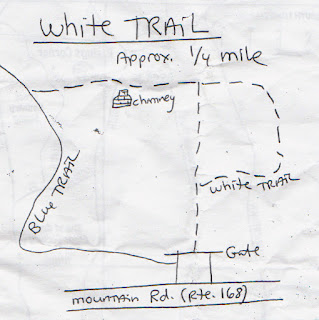
I picked up a trail map kindly supplied at the start of the trail (scanned at the bottom of this post) and started up the White Trail, quickly passing another chimney, and very shortly joined the blue. The map at left is from my gps route (click it to enlarge).
 |
| Chimney on the White Trail |
There is supposed to be the remains of another cabin along the Blue Trail, but I couldn't find it and suspect it may be another casualty of the massive powerline work that's going on in a couple of towns up here. Part of the trail near the powerlines was likewise obliterated, but turn right along the powerlines for a bit and look for the blue to re-enter the woods on the left. The top of West Suffield Mountain is not far after that.
 |
| Gazing out over Massachusetts from West Suffield Mountain |
It was a fast walk along the ridge in search of the end, racing with the sinking sun and trending down the hill, when all of the sudden there it was. Two horizontal blue blazes.
 |
| So this is how it all ends. |
 |
| Sumac |
On the way back, the low light of the sinking sun made for some nice fall foliage shots.
 |
| Sweet Fern (not actually a fern) |
 |
| Red Oak |
The Connecticut NET journey is not over! There's a new section down in Guilford that was just completed in 2012, and then there's that long section of the Mattabesett Trail that looks like a spur off the mainline NET. And after that, there's always Massachusetts.
I will leave you with the hand-out maps for West Suffield Mountain:


It's been fascinating reading your blog - discovered it yesterday on a Google search. I did a very similar series of hikes in 2007, only I started in Middletown and got up to around Westfield, Mass. Good luck in the future!
ReplyDeleteLooks as though someone listened!
ReplyDeletehttp://newenglandtrail.org/get-on-the-trail/ct-net-section-21-metacomet-trail
"Until May 2013, this section had been a roadwalk along Old Mountain Road (CT) and Warnertown Road (MA).
After 40 years, the trail has been returned to its original home on West Suffield Mountain, and meets MA NET Section 01 at the CT/MA border near Rising Corners in Southwick, MA."