 |
| Kings Hill Road |
This was the last day of hiking New Hampshire's "Ghost Trail" route between Crawford Notch and Mt. Sunapee. The original plan for the day was to stop at the foot of Mt. Sunapee and save that for the following morning prior to heading home. But I made great time and finished up early. I parked at the hiker lot on Kings Hill Road "Maple Leaf Natural Area" (thank you Sutton Conservation Commission) and headed west up the narrow gravel road.
 |
| Also Kings Hill Road (extra points if you see a dog) |
About half way up the hill, the drivable gravel road split, with the 'maintained' road going off to the left and the SRK Greenway continuing straight up the hill on a deeply eroded road bed. This seemed to be a very old road that's been more or less abandoned, but has a nice historic feel to it. Stone walls on either side, and old ruins at the top of the hill. Very New England. Back in the day, maybe it was one of the major roads in the area.
 |
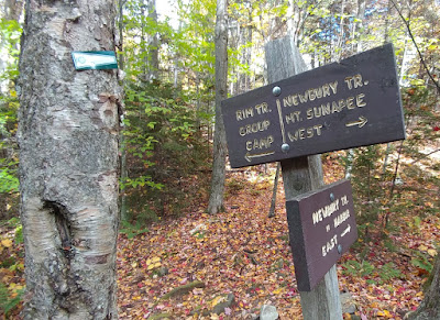
Looking back at an easily missed junction westbound -
Trail goes into the woods left of the gate |
On the way back down the hill, there's a spot that hikers heading in the opposite direction (east) could easily miss. In the above photo, the SRK Greenway heads into the woods to the left of the gate.
 |
| Road walks can be nice |
After some more quiet road walking, the SRK Greenway took up with Stoney Brook Trail, which I enjoyed. No complaints there. It was pretty easy and I was making fast time with little effort.
 |
| Stoney Brook Trail |
After passing through a big empty trailhead parking lot, the trail came out near Chalk Pond. The pond was a bit disappointing, since you get but a brief glimpse of the pond between private dwellings.
 |
| Coming out onto Chalk Pond |
Then there was more wood-road walking up a good hill leading to Fishersfield Trail. This part of the hike was the slowest and most tedious, with uneven footing, but eventually the trail came to the last of the woods before heading down the road towards Sunapee, and I stopped for a break. It was only 11:00 am. How did that happen? It was too early to stop for the day. Also, my husband was in the middle of an 18-hole round of golf. So what the heck, I decided to go up Mt. Sunapee.
 |
| Deer and Turkey registration stations below Mt. Sunapee |
It was amazingly hot under the sun for mid-October in New Hampshire, near 80-degrees. I sort of wanted to go for a swim in the lake. And I had pictured temps in the fifties. Ha! You just never know.
 |
| Public dock at Lake Sunapee |
 |
| Don't do it. |
I couldn't stop anywhere for refreshments since I had a dog in tow, so I grabbed some drinking water at the end of a public pier on the lake instead. (I later replaced that with water from a stream on Mt. Sunapee). There was public parking at the pier, but it's not the closest parking to the Mt. Sunapee trailhead, which is "at the caboose." I mention this because we did have some confusion when it was time for me to get picked up.
The SRK Greenway follows Newbury Trail up Mt. Sunapee, but there is strictly no parking on Lake View Avenue where the trail begins. People need to park at the caboose. That's right, and if you don't know where the caboose is, just head back down Lake View Avenue until you get to Lake Sunapee and it's right there. Hard to miss.
 |
| "Park at Caboose" |
 |
| Back at Lake Sunapee: Here's the caboose where you park. |
 |
| Lake Sunapee at the Caboose. It's a nice spot. |
At any rate, I was rather hot and tired before I even started up Mt. Sunapee, but eager to arrive back at the M-S Greenway and see Lake Solitude once again. It was back in 2018 that I first came through on the M-S Greenway, heading north towards Canada. I remember having such a wonderful and peaceful backpacking trip up Mt. Sunapee (pretty sure I heard a moose trot past my tent at night) until I arrived at Lake Solitude, when all the sudden there were noisy hikers yelling about what they were going to have for lunch. On the opposite side of the lake. And I could hear every word they were saying. I finally had to put ear plugs in. Hopefully Lake Solitude would live up to its name this trip.
 |
| Heading up Mt. Sunapee on the Newbury Trail |
The trip up was pretty good as the weather started to change and get a little dramatic. Low clouds skimming by, and thankfully cooler. There were a few dayhikers here and there and issues with us trying to keep our dogs apart. But overall, not too bad.
 |
| A look back |
Part way up was a nice overlook back towards Lake Sunapee. It was the only vista on the hike up to Lake Solitude. There are overlooks if you go all the way up to the summit of Mt. Sunapee, but that wasn't my plan since I'd already done that in 2018.
 |
| Fall color heading up Sunapee |
And finally I reached the "Jack & June Junction" where the SRK Greenway and M-S Greenway meet. I'd been here before and had just completed one very big circle. North to the Appalachian Trail at Moose Mtn in 2018, the A.T. to Bretton Woods in 2019, and then heading back south in 2021 from Bretton Woods to Sunapee via the Cohos and Ghost Trail. So cool.
 |
| Jack & June Junction |
I could have stopped there, but I really wanted to continue to nearby Lake Solitude, and so I did. In my mind, this was the point where the New Hampshire "Gap" alternatives diverge, although technically the routes diverge at the Jack & June Junction. From this point, you can head north on the SRK Greenway and then follow some snowmobile trails towards Moose Mountain, the fastest way to the Appalachian Trail. Or you can go east on the SRK Greenway over Kearsarge and Ragged Mountains to Mt. Cardigan. From there, some people head north towards Mt. Moosilauke and the Appalachian Trail. And others might head east from Cardigan along the "Ghost Trail" through Hebron and Plymouth and on to the trails of White Mountain National Forest by way of Whiteface and Carrigain Mountains. All routes lead to the Cohos Trail near Bretton Woods, which takes you to the Canadian border.
 |
| Lake Solitude |
This time, when I reached Lake Solitude, all was still.
No comments:
Post a Comment