 |
| Appalachian Trail in New Hampshire |
Back on the trail for a few days of backpacking! Everything thing is different now that I've reached the Appalachian Trail at the western edge of the White Mountains. The terrain is more dramatic and the weather is slightly cooler. But what really sets this trail apart from the New England Trail, M-M Trail, and Monadnock-Sunapee Greenway, is the heavy use by long-distant backpackers and the infrastructure that has evolved to support that.
 |
| Bog Walk near Goose Pond Road near Lyme |
It seems counter-intuitive, but the trail here up in the mountains of New Hampshire is much busier than what I typically encountered in more heavily populated Connecticut or Massachusetts. Sure, there are hot spots along the New England Trail such as Mt.Tom or Heublein Tower that are always crowded, but there are long stretches of trail in southern New England where I might not see another hiker all day, especially during the work week. It was in part that unexpected solitude in the midst of the suburbs that made the New England Trail so interesting.
 |
| Bunchberry Dogwood |
But here on the Appalachian Trail there is a steady trickle of thru hikers who started out in Georgia, some as early as February, eager to arrive at Katahdin in Maine before the autumn snow squalls. There are also "Section Hikers" who are backpacking a section of the trail. All of them are hardcore, seasoned backpackers making good time. I didn't see any day hikers on this trip, although there was one trail runner.
The objective for my New Hampshire trip was to hike (mostly backpacking) from Goose Pond Road in Lyme in at the bottom of Moose Mountain up to the base of Moosilauke in Benton, where the high peaks of the White Mountains begin. There are some good ups and downs on this section, but the elevation never gets above 4,000 ft. I don't normally hike much during the summer, but starting with Mt. Moosilauke, the Appalachian Trail will traverse over a number of 4,000 footers where the weather is normally much cooler and even dangerous at times if one is unprepared. So I was hoping to hike this first section of the A.T. after mud and black fly season (April-June), but before the worst of the summer heat had arrived (July-August). I got a mild version of all three, so I guess I'll call that a success. Then I'll be free to hike the high peaks during the summer months.
 |
| Day 1: Goose Pond Road to Smarts Mtn |
 |
| Mountain Maple |
After the four hour drive up from southern Connecticut, hitting the trail in the North Woods was pure joy. Many of the plants are completely different from Connecticut and I had my eye out for a tree species I never knew existed until I was paging through a field guide for New England mountains shortly before the hike: Mountain Maple. I found it flowering within the first hour or two near Holt's Ledge.
 |
| Holt's Ledge |
The climb up to Holt's Ledge was about 1,000 feet up, and if this was Connecticut, that would have been the Big Climb for the day. But we're closing in on the White Mountains and 1,000 ft is nothing. Holt's Ledge is part way up Bear Hill or Bear Mountain. There were nice views from the top of the cliff and I stopped for lunch. A peregrine falcon called from the cliff, though I never saw it. The trail descended to cross Dorchester Road and passed through an overgrown meadow next to pond with lots of Lupine in bloom. The Lupine is an escaped garden variety from Europe that has naturalized so well it's become symbolic of the north country. Even through the meadow was terribly overgrown and I had to wade through the 4-foot grass, it was easy to figure out where the trail was. So many people walk it.
 |
| European Lupine near Dorchester Road |
 |
| Mountain Wood Sorrel |
A great advantage of hiking on a busy backpacking trail like the A.T. is that there are guidebookd and phone apps set up to help you out. There's a
guidebook that everyone carries down the trail (the thru hikers carry the entire book while the section hikers often just photocopy a few pages, as did I). It tells you in a mileage format where the shelters, tent sites, and reliable water sources are, as well as descriptions of some of the towns and key services along the way. When I was hiking the New England Trail, I had no idea where I might find water and there were a few times I stashed some big bottles of water along my route up ahead.
 |
| Last water for over 8 miles - Grant Brook South Branch |
 |
| Only 412 miles to Katahdin |
I was hoping to camp at the tent site on Smart Mountain. The guidebook noted a "weak spring" at the top, and I thought we've had a pretty wet year and expected there would be water. But on a lark, the day before heading up, I installed a phone app called Guthook which turned out to be really useful. I paid a few dollars for the New Hampshire section of the A.T. and set the app up for off-line use in case there was no cell service (good call). The Guthook app shows the water sources, camping areas, etc., your location along the trail, and how many miles it is to whatever feature you're interested in.
I pulled up the Smarts Mountain tent site and found a description of the site and comments from people who had recently been there. One comment from only a week or two earlier was, "Do yourself a favor and carry up your water." The spring had dried, and other hikers had to descend a side trail for "a couple miles" to find water. Good to know. Very good to know. Thank you. So I was careful to identify the last good water source before Smarts Mountain and fill up. I think I had nearly five liters, which was more than I needed, it turns out. But the next reliable water source was in nine miles, and there would be a 2,000 foot climb in hot weather and overnight camping prior to that.
 |
| Smart's Mountain, the lower part |
Smarts Mountain, at elevation 3238 feet, is a good warm-up for the serious mountains further along the trail and the highest point yet coming up from Long Island Sound (Mt Monadnock is slightly lower). There's a moderate 1,000 foot climb, a long level section along the shoulder with lots of exposed rock, and then another 1,000 foot climb that's steeper but not technically difficult.
 |
| Milk Snake |
A good-sized Milk Snake was hanging out on the rock. I've never seen a Milk Snake in Connecticut. The only other time I've seen one was on the top of Cadillac Mountain at Acadia. This one was pretty aggressive and lashed out at me and I wasn't even that close. The only other snake I've encountered that was so aggressive was a Copperhead. The two species have similar markings and are sometimes confused with each other, so I wonder if the Milk Snake was mimicking a Copperhead. It was also weirdly twitchy.
 |
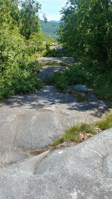
| Smart's Mountain Part 2, from Smart's Mountain Part 1 |
 |
| Pink Lady Slippers still blooming |
By the time I got to the top of the first half of Smarts Mountain, I was getting pretty hot and tired, so I stopped for a break. I wondered what mountain that was in the distance. I noticed a teeny tiny fire tower on top. That's when I realized I was looking at the top of Smarts Mountain, my destination ha ha ha. It seemed so far away. Clearly I needed to recalibrate my flatlander sense of proportion up here in New Hampshire.
There was a long relatively level stretch before the trail finally started heading uphill again. I noticed some of the plants going backwards in season as the elevation increased, including some Pink Ladyslippers in bloom. In Connecticut, those had bloomed a good three weeks earlier and were now setting seed. Clintonia had been setting seed down below but now I was seeing them in bloom.
 |
| Nearing the top of Smart's Mountain |
Although the climb up was mostly pretty easy (not many scrambles), there was one little stretch up seeping rock that had a log stairway followed by iron rung steps. That was a first along the route up from Connecticut. I don't think it will be the last, though. The iron steps weren't bad going up, but looking back down I was glad I didn't need to try them in reverse.
 |
| Iron rungs |
Water is heavy. An extra ten pounds, to be exact. As I struggled up the hill with all this water, a hiker coming down claimed I was near the top. "It's a lie!" I said. "It's always a lie!" He snickered. But it turned out to be true, and just like that, I was at the Smarts Mountain tent site. Whoohoo! Old Lady Flatlander did it!
 |
| Yes! |
The Smarts Mountain tent site had only one other person, a thru hiker who started in February and was sleeping in a tent hammock at the gorgeous overlook. After complaining about the black flies, he invited me to set up tent at the overlook, where there was also a fire ring, and I was tempted, but imagined it getting crowded with more hikers coming in.
 |
| View from Smart's Mtn Tent Site |
Instead, I found the perfect private tent spot. The first order of business was put on my bug jacket for the mosquitoes and blackflies. It's just netting fabric treated with permethrin, but it works great. The bugs during this trip were not horrible as long as you were walking and had bug juice on. It was in the evening trying to set up a tent when they got really annoying.
 |
| A nice private tent site |
After setting up camp, I set out to find the fire tower, which was just a few hundred yards up the trail. It a big one and I'm not fond of heights, but I went all the way up and found the top was open. It was so full of trapped house flies and other assorted bugs that I quickly exited and took my pictures from the steps.
 |
| Climbing up the fire tower on Smarts Mtn |
It was gorgeous in all directions. To the east was the flat top of Mt Cube, which the A.T. would be crossing over next. Mt. Moosilauke loomed beyond that in the distance.
 |
Looking east towards Cube Mtn (left) and Moosilauke
|
Dramatic rain squalls tinted with pink threatened to the west. Wow. What a great end to the day. But wait, it's not over yet! After it got dark, a big lightening storm parked itself over Smarts Mountain and stayed there for about an hour. Holy cow. Being in a tent on the highest point around no longer seemed very wise. One lightening strike was so close I heard it sizzle. But eventually it passed an I was able to get a few hours of sleep.
 |
| Rain squalls to the west |
Hike distance: 9.4 miles. Elevation gain: +4240' and -2000'.


No comments:
Post a Comment