 |
| Turkey crossing Northfield Road |
What a great way to start the day: a commuter mug of hot coffee, a flock of turkey scampering across the road, and a hike up Mt. Grace from Northfield Road.
 |
| Richmond Reservoir, here I come |
Day Three of our mini-vacation had the shortest hike. It's 6.5 miles from Northfield Road at the base of Mt. Grace, to Richmond Road at Richards Reservoir. I looked at going further, but it seemed like the next possible pick up point was pretty far down the trail.
 |
| Heading up Mt Grace with a good cup of coffee |
It was a Monday, and most people were working or in school. A pair of retired-looking hikers came down the mountain as I was headed up, and these were the last two people I saw on the trail for the next two days. We exchanged our appreciation for the lack of crowds.
 |
| Hophornbeam Seeds |
The left foot was doing better today. Really? The rest of me was getting pretty sore and tired after the previous two days of hiking, but the bad foot was improving. Huh. The podiatrist had said something about a possible nerve issue. I decided that must be it: It's fake pain. From this point on I would pretend it didn't exist.
 |
| Teaser views on Little Grace |
The tired, stiff legs didn't want to climb up Mt. Grace, though. I made a decision that when I finally get to Mt. Monadnock I would have to start out completely fresh.
 |
| Share the trail with the phone poles |
The moderately steep trail went up and up and up, cresting briefly at the top of Little Grace, and eventually following some powerlines.
 |
| Mt Grace survey benchmark |
There's an old fire tower at the top, and it's the only way to get a view. I'm not crazy about heights, but that's what the railings are for.
 |
| Warwick Fire Tower - a long way up |
I got all the way up those steps only to discover the observation deck was closed. So I clung to the railing and took my pictures from the steps.
 |
| The top is closed :( |
And there was Mt. Monadnack, closer than yesterday. The end is truly in sight. And it seems really high.
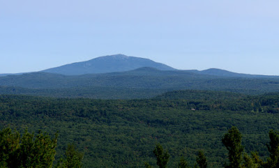 |
| Mt Monadnock! |
I looked back the way I had come. The foreground was pretty gentle with the low rise of Stratton Mountain and Northfield Forest. There were more low ridges beyond that. But far in the distance was the familiar shape of a traprock ridge.
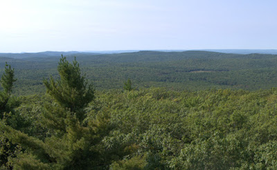 |
| Looking back the way I came |
Could that be Mt. Tom and the Seven Sisters off to its left? Or was it Mt Toby? Or something else? If anyone knows, please leave a comment.
 |
| Is that Mt. Tom? |
And what about the distance peak far, far off to the north through the haze? Mt. Washington?
 |
| Looking north ... Mt Washington maybe in the distance? |
And that was it for the views, so down the hill we go for some happy hiking. It was a pleasant walk down Mt. Grace. Not steep.
 |
| I see we're in a good mood |
The AMC has a shelter towards the bottom near a stream, so I took a little break.
 |
| AMC Shelter |
Someone had left a bag of colored chalk in the shelter, which seems like a brilliant way to get people to stop carving their initials into it.
 |
| They left a bag of chalk |
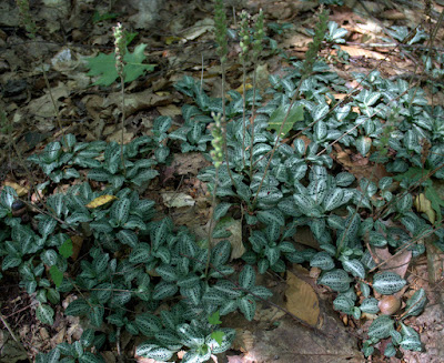 |
| Rattlesnake Plantain |
 |
| A beautiful walk |
It was a quick walk down a woods road to Route 78 and then Section 17 of the M-M Trail was complete. That was my goal for the min-vacation. But why stop there with the New Hampshire border so close and the weather so perfect? I continued on to start the next section.
 |
| Section 18 begins |
Section 18 is the last full section of the M-M Trail in Massachusetts. It started out through an area with lots of ATV activity, heading uphill. The trail turned onto a gravel street for a bit. I like how the street crossings have wooden signs telling you what street you're at. This one was Old Winchester Road. My phone showed a bar at the top of the hill and I was able to text my husband my location with confidence.
 |
| Old roads and ATV tracks lead to Richards Reservoir |
This part of the state has spotty cell phone reception. In general, the high places get a signal and the low places do not. I learned to check my phone at the hilltops and text my location. Even then, the signal was often weak. We learned not to text pictures, because they would jam things up for hours.
From Old Winchester Road, the trails turns east and follows an old woods road to Richards Reservoir. I found a beautiful silver cross laying on the side of the road. Looks like it may be a family heirloom, so I'm trying to find the owner.
 |
| Found: Does this belong to you? |
There were plenty of fungi during the trip, the prettiest of which may have been the Amanita fruiting away in the middle of the old road. I'm not sure if it's the Yellow Patches species or the Fly Agaric. Both are poisonous and the latter causes hallucinations. It got its name from when people in the Middle Ages mixed it with a bowl of milk to kill flies. When flies drank the milk they became stupified and drowned. I wonder if any cats drank the milk and started acting silly.
 |
| Amanita flavoconia "Yellow Patches" or muscaria "Fly Agaric" |
When the reservoir came into view, the trail turned off the old road to follow the ridgeline above the pond. Trees blocked the views, but you could tell the reservoir was down there.
 |
| Richards Reservoir |
The trail gradually got closer to the water as it meandered along, going down hill, but still no views until it crossed the powerline corridor. At this point the reservoir was narrow and rather swampy. I didn't realize it at the time, but I would be at the top of the hill under the powerlines the next morning. Looks pretty close, but it's a rather long, meandering walk to get there.
 |
| Wave to my future self |
The path finally became close enough to the edge of the swamp for me to have a seat in a bed of pine needles and pull off my boots for a spell, and enjoy the view. I studied the trail maps. It seemed pretty early in the day, and I didn't want to stop at Richards Reservoir when I was getting so close to the state border. The AMC map showed a Kelton Road crossing the trail a few miles ahead. Maybe I could get picked up there. I began adding up the mileages, but there seemed to be some discrepancies. And was Kelton Road open to traffic? Hard to say. It did show up on Google Maps. I was leaning towards trying to make it to Kelton Road when my husband texted that we was on the trail walking towards me. That was very, very fortunate, because Kelton Road was much farther down the trail than expected, and was a very rugged 4WD road, as I learned the next day.
When I got up from my break, my backside was soaking wet. Turned out I sat on the hose for my new water pack and it emptied out where I was sitting. Need to lock the mouthpiece on that one! Lesson learned.
 |
| Emergency outlet? |
A few minutes down the trail and I met up with my husband. Rounding the northern tip of Richards Reservoir, there's a man-made channel that comes up to the path and stops. Odd for the backside of a reservoir. Checking a map, the channel seems to point toward the top of a small stream heading away from the pond in the opposite direction from Black Brook, the stream that was dammed to create the reservoir long ago. Maybe this is an emergency spillway.
 |
| A bit of a bog |
The NET circled around the reservoir in a real meandering way, with occasion views of the north end of the reservoir. Parts looked like they were transitioning to a black spruce bog.
Just before reaching the car, I heard a commotion behind me and caught the tail end of one of those long, dramatic trail tumbles being performed by my husband. He got up dusted himself off and seemed to be OK. And that's when I tempted Fate: "You should have a trekking pole. I never fall now that I use one." And Fate chuckled quietly to herself, as we shall see in the next post.
On the way out, we stopped for more turkeys to cross the road. I began to crave cranberries.


The cross! I have the same one very old has been in my family for many years. Hope you find the owner
ReplyDelete