 |
| I am so sorry, Florida. |
On the second day of our stay in the Quiet Corner we woke up to the news that Hurricane Irma was hitting the Florida Keys. But it was so pleasant here in Massachusetts. I felt a little guilty.
I expected my left foot to be much worse in the morning after hiking seven miles the day before, but it actually felt about the same as usual. No better, and no worse. And that was great news. I really thought I'd be sorry for pushing it.
 |
| 8.2 Miles to Northfield Road |
Section 17 is 10.2 miles long, ending with a climb up Mount Grace. That's more than I was up for in one day, especially with a bad foot, so my plan was to hike to Northfield Road, a distance of 8.2 miles, and leave Mount Grace for the next day.
 |
| People don't bring maps |
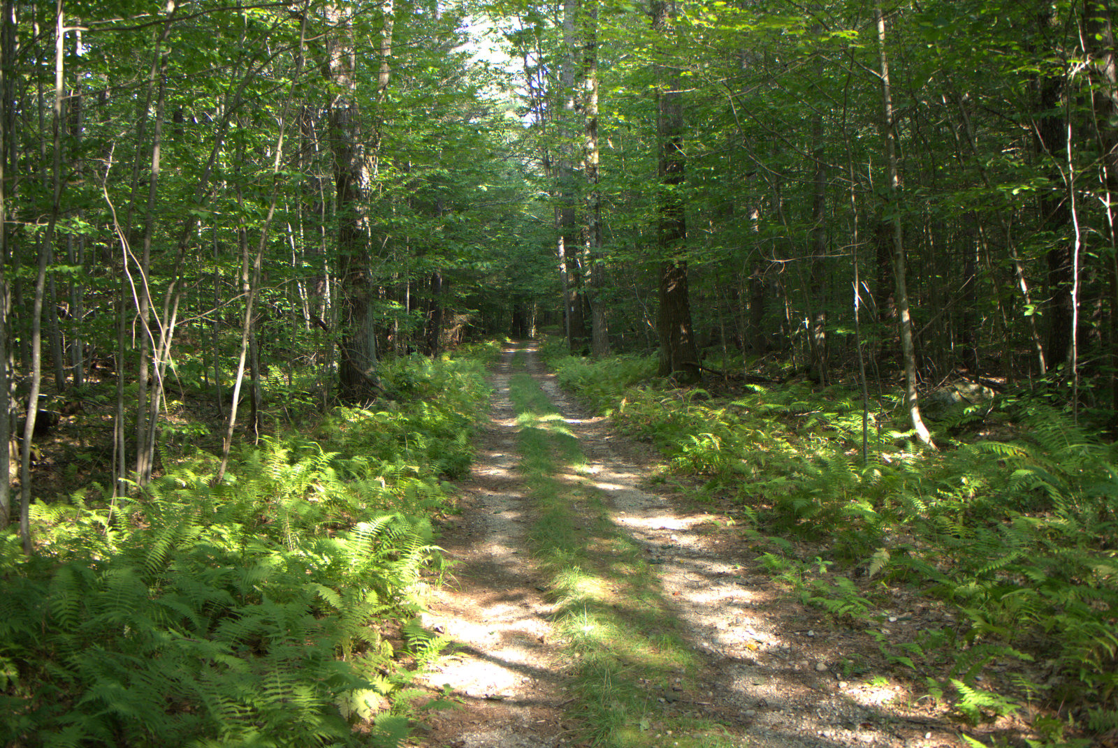
The Richardson-Zlogar cabin on Stratton Mountain is definitely the highlight of this section. In fact, it may be the highlight of the NET from Millers River to the New Hampshire border. It's a lovely stroll up to the cabin. It wasn't long before I passed a group of what looked like Boy Scouts and their involved fathers hiking down from the cabin. The dads look like they were carrying some pretty heavy packs and possibly did not get much sleep the night before, but they had almost made it and there was light at the end of the tunnel.
 |
| A beautiful morning stroll |
I got into a nice walking rhythm carrying my commuter cup of coffee down the trail. You know when you're deep in thought, and that ancient part of your brain screams out "SNAKE!"? And then you look down and it's a hose or a stick? I had one of those moments when my brain interpreted a snake up ahead in my peripheral vision. But then it turned out to be a root. A very snake-like root, though, and as I stepped over it I turned my head back to marvel at its snakishness.
And that's when I stepped on a snake. A real one. The big fat garter snake bolted out from under my feet and froze beside the trail.
 |
| SNAKE!! Wait, no, not a snake |
 |
| SNAKE!! |
Mother Nature had just played a pretty good mind trick on me. Did that really just happen? A group of mountain bikers came up the trail just then, and I turn to them, pointed, and said stupidly, "I just stepped on that snake." But we all had fun admiring the big fat garter snake and it's likeness made of root. Then the mountain bikers were on their way and I didn't another person for the rest of the hike.
 |
| Great Swamp or Hidden Pond |
After about a mile of traveling east, the trail comes to Great Swamp (aka "Hidden Pond" on the entrance map) and turns north to head up Stratton Mountain. It was worth a short bushwhack to the shoreline for a break. I was happy to notice my left foot wasn't bothering me too bad, which was a real surprise.
 |
| Passing through a Hemlock forest |
I still took it nice and slow. I like knowing that I have all day long with nothing to do but walk and no reason to rush it. The relaxed steps become almost meditative, an antidote to daily to-do lists. No tasks to prioritize. Just the footsteps and leaves and trees and rocks. All day.
 |
| Heading up to the cabin |
It was a gradual climb up Stratton Mountain to the cabin clearing. The camp was deserted and I had the majestic view all to myself. It was amazing.
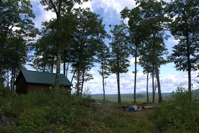 |
| Richardson-Zlogar Cabin |
In addition to the cabin there are wooden platforms for tents and a large fire ring surrounded by benches. I could imagine the Scouts that I had passed on the way up sitting around a roaring campfire the previous night. I wondered what the sky would look like at night under the stars and whether the distant mountains would be visible on the horizon.
 |
| Trail Register. Mt Grace & Monadnock in background. |
There's a trail register at the cabin for hikers to sign in and I did so. Over the winter, my husband and I built a trail register for a section of blue-blazed trail that we maintain for CFPA in Connecticut, so now I'm newly interested in how each trail register is constructed.
 |
| Hmmm.. Their trail register has pencil holder slots. |
The view faces east with Mount Grace in the foreground and Mount Monadnock beyond. I think the first view of Mount Monadnock along the NET had been back at Mount Tom. The end of the trail is getting closer.
 |
| Mt. Grace and Mt Monadnock |
The cabin is located on private property owned by Trail Heroes Sam and Barbara Richardson. Here is an excerpt from
a web page about the cabin:
"In 2011, NET landowners and maintainers Sam & Barbara Richardson donated a Conservation Restriction to the Town of Northfield on a 38 acre lot on Stratton Mountain." I told you they were heroes.
 |
| True Class. |
But there's more: "This cabin was built by Appalachian Mountain Club-Berkshire Chapter volunteers in the Fall of 2011 and the Spring of 2012, whose combined efforts contributed over 1000 hours of work. The name "Richardson-Zlogar..." reflects the special efforts of one volunteer in particular-Mike Zlogar, who proved himself invaluable throughout the course of the project. Mr. Zlogar is also a long-time NET/M-M Maintainer."
Some people are amazing.
 |
| I still don't know how to go northbound... |
When it was finally time to head on down the trail, I did have some trouble finding the trail northbound. There were blazes heading straight for the cabin that seemed to be northbound, and then nothing. It turns out those blazes leading to the cabin reflected a short spur off a hairpin turn and not the main trail. I finally figured it out when I saw a sign for the West Vista and headed in that direction.
 |
| West Vista...What the heck??? |
The West Vista made me laugh out loud. There's some kind of Stonehenge rock work going on there that I don't fully understand but enjoyed none-the-less.
 |
| Hobblebush berries |
As the trail heads north towards Alexander Hill Road, it passes through an area that was recently logged over and overgrown. The logging had let in the sunlight and the brush was growing up fast over the trail. It's the type of vegetation where the blazes can go missing in the blink of an eye. It was passable, but won't be for long. That's why you want a good map.
 |
| OK, this part is getting a little hard to follow |
The Alexander Hill Road Trailhead appears to be the most popular access point for the trail network on Stratton Mountain. My husband and I had played with the idea of him parking there and heading south while I was head north from Gulf Road, but he didn't get there until after I had passed. (He walked up to the cabin based on my recommendation and really enjoyed it).
 |
| Alexander Hill Road Trailhead |
There were a number of hemlocks throughout the region sporting dramatic fungi known as the Hemlock Varnish Shelf
(Ganoderma tsuga). It's woody and looks like it has a coat of varnish, hence the name. People who are into medicinal plants refer to this as the Hemlock Reishi, and the Chinese know it as songshan lingzhi. It has a long history as a sort of Panacea for all sorts of ailments.
 |
| Hemlock Varnish Shelf |
For a mile or more after the Alexander Hill Road the NET loops around and meanders, and you don't seem to get very far very fast. Checking my time and my progress, I began to wonder if I should pick up the pace.
 |
| Hobblebush invading the trail |
And then the trail crossed a stream and took a right onto an old road. This was a branch of the 5th Massachusetts Turnpike, 1799-1832. Per Wikipedia:
- "Whereas the high way leading from Northfield …is Rocky & Mountainous, & the expense of straitening, making & repairing the same through the said Towns so that the same may be conveniently travelled with Horses & Carriages is much greater than reasonably ought to be required of said Towns; Be it therefore Enacted…"
And with that, in 1799 a corporation was granted the right to build a road and collect tolls. Most of these roads are today busy roads, so hiking down an old one through the forest is different.
 |
| Heading east on the old 5th Massachusetts Turnpike |
The various trail descriptions mention that the trail follows the old turnpike on Section 17, and I thought this might be the place, but I wasn't sure. Back home I found a custom Google map showing the route. Took a screenshot of that, and a screenshot of the NET online map, and did an overlay in Google Earth, and here's what it looks like:
 |
| Map overlay: 5th Mass Pike (red) and NET (faded brown line) |
The NET is on the lower layer and faded, while the turnpike is in red. So that confirms it.
The trail/turnpike crossed Bass Road and then a stream that must be part of Bass Swamp. The next landmark would be Shepardson Road. I was making great time now, but my left foot was in agony and I had to stop and take my boots off for awhile before continuing down the old road.
 |
| Upper end of Bass Swamp |
It seemed like Shepardson Road never came, and I wondered if the trail had been rerouted. Finally I saw blacktop up ahead and the trail curved right to follow it.
 |
| Really? State Forrest boundary or what? |
Wait, that's Northfield Road. What happened to Shepardson Road? Who knows. Maps can be deceiving. Fortunately, it didn't really matter, and my ride had just turned up. Great timing!
 |
| Northfield Road at the base of Mt. Grace |
Mt. Grace waits on the other side of the street, but that's for another day.


Hi Teresa,
ReplyDeleteWe were interested in using some of your awesome photos to help us promote the New England Trail. Would you be open to us using your photos and crediting you as the photographer? Please email us at npausweiler@outdoors.org if you are interested. Thanks!