Thursday, September 15, 2016

M-M Section 6 Mt. Tom

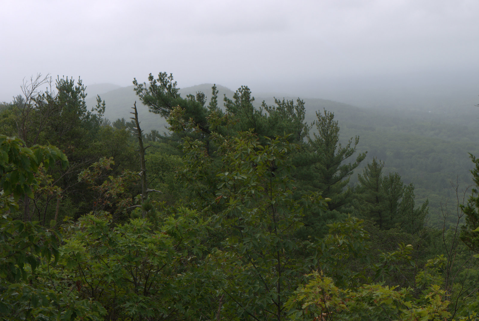
Mt Tom, looking NE towards the Oxbow lake and CT River.

Mt Tom is probably the most popular destination along the M-M Trail, with lots of dramatic views, and much has been written about it. The initial ascent is moderate but relentless, climbing 600 ft in less than half a mile, but once you're at the top, the rest of the hike is much easier as you walk along the top of the cliffs for about the next mile. The trail then descends to a notch with a paved park road (and a drinking fountain in season), then continues on to the Goat Peak tower with the best views of the entire New England Trail so far. After that is a recommended detour to the Eyrie ruins overlooking the Oxbow, and then an easy descent to the boat ramp on the Oxbow.

Location Map
There is pull-off across the street from the Holyoke Animal Hospital for maybe ten cars that was empty at 8:30 am on Thursday morning but looks like it fills up pretty quickly during the weekend. The address for gps is 320 Easthampton Road, Holyoke (MA 147).  The destination for this section is a state boat launch off MA 5 at the Oxbow, or you can stop at Underwood Lane to skip the roadwalk at the end. Section 6 technically starts back further on MA 141 (completely previously) for a total length of just over six miles and reported elevation gain of 1775 feet up and 2190 feet down over the course of the entire hike.

Looking south along the Metacomet Ridge, with quarry dust at Section 3
It's always rewarding to look back and see where you already hiked. A cloud of dust hung over a quarry that must be the one Section 3 detours around. The distinctive trap rock ridge profile of a taller mountain in the distance looms behind it. I wish I knew which one. Talcott? (click the photos to enlarge).

Looking north
There is obviously a lot of history along this section. There was a huge Summit House at the peak where the antennae farm is now located, and remnants of this remain. And there was a train that climbed the hill steeply to the summit house, now converted to a park path.

Looking west through a notch in the cliffs
The trail through here is relatively easy, but there are still some ups and downs and the occasional short scramble.
I admire the sentiment, if not the spray paint.
Bristly Aster 
"Not all who wander are lost." May I say that this applies to women as well as men? I mention this because I am often asked if I'm lost, or looking for the trail, or whether I'm OK. This happens when I set my pack down to pull out an apple. Or stop to look at my letterboxing clues. Or check my map. Or my gmail.  I can't get mad, because people are just trying to be helpful. More bothersome is the tone of voice with which I'm asked these questions, a tone similar to one used on a small child while you pat their head. Both men and women do it. Before asking the question, think to yourself, "Would I talk this way to a guy hiking by himself?"

This day, however, I had a hiking partner, so no one asked if I was lost. We had a great time poking about the ridgetop and taking a break for lunch towards the end of the cliff section. After this the trail drops down through the trees to a park road (Reservation Road), where we were able to refill our water bottles at a drinking fountain.


Lunch break

From there, it wasn't far to Goat's Peak, with a bench alongside the trail and a viewing tower a short ways up a path. 

Overlook near Goat's Peak. 

Wood Asters
Do the Goats Peak viewing tower. It has 360° views. I've hiked the Metacomet Ridge now all the way from Guilford, CT, and the only view that compares is the one from Heublein Tower on Talcott Mountain. I think the Goat's Peak one is better, though, because you're not inside a solid structure looking through glass, but on top a more precarious deck with the wind blowing through your hair. It feels more dramatic. 

The Goat's Peak tower is breathtaking. 
Looking NE along the Holyoke Range. 

Zoom view south including Hartford and some trap rock ridges
(click photo to enlarge)
Continuing on down the trail, a great view of the Oxbow opens up. This is a former bend in the Connecticut River, and is still connected to the river. My plan for the next day was to explore the Oxbow by kayak with my husband, then cross the Connecticut River and continue hiking up Mt. Holyoke. More on that later.

The Oxbow
Overlooking the Oxbow, built into the side of the ridge, are the ruins of "the Eyrie." It's a short detour off the M-M trail, but worth it. Just another summit house that burned down, but there's something different about how this one is laid out.

"The Eyrie"
Columbine foliage at the Eyrie ruins
From the Eyrie, the trail follows an old carriage path down the mountain. It's easy walking, and there's not even any loose trap rock to trip over. When the trail came out onto Underwood Drive, we decided to walk a few more minutes down the road to the state boat launch and official end of this section. On a Thursday evening, the boat launch was nearly empty. 

Something small was jumping in the water, catching the sun and making the water sparkle. We asked a fisherman pulling out his boat what it was, and were told it was shad jumping. You can see some of them in the photo below.


My husband was there to pick us up, and after some car shuttling, we headed to our hotel room for a long weekend. On the agenda was kayaking, more NET hiking, shopping, golfing, eating out, and the Big E in Springfield. 

Tuesday, September 6, 2016

M-M Section 5 East Mtn North Spur


I loved this section. It's classic traprock ridge hiking, without the crowds or ATVs. Didn't see a single person all day.  The sounds were the wind and the birds and sometimes airplanes taking off. Lots of scenic vistas on this one. The trail was well-maintained and I never once had to pause to figure out which way the trail went. Thank you, trail maintainers. Your work has not gone unnoticed.
Buttonbush along a pond near the beginning of Section 5
The remnants of Hurricane Hermine were stalled off the coast of Long Island, giving off a good stiff breeze and some bouts of mist. As the storm inched closer to Connecticut, I took a drive to Massachusetts to spend the day hiking. Another hot spell was forecast for the rest of the week. Hottest summer ever. It just won't quit. But on this day the outer bands of the storm spread into Massachusetts, holding off the heat for a day.


Section 5, West of Holyoke
Section 5 is directly west of Holyoke and is either 5.7 miles long (M-M guidebook) or 4.1 miles (NET maps and website). I lean toward the latter, but you never know.

Google Earth view looking northbound
Google Earth shows how the trail follows the ridgeline, giving that illusion of wilderness in the midst of suburban sprawl.

Mist  along the ridge from Storm Hermine


Cloudy weather makes for better trail photos. It was a short section, and probably the last I'll be lugging my 'real' camera around for awhile, so I took lots of photos.

New England Aster
Fall asters and goldenrod were in bloom. The aster in the photo above is New England Aster, not the more common Wood Aster. I don't see this one very often.


I love the distinct assemblage of trap rock ridge plants that you can find growing from Guilford, Connecticut all the way along the ridge to Holyoke. I rarely see Bear Oak unless I'm at a rocky scenic overlook.


Bear Oak
Nearby was what looked like immature Huckleberries, but in September? Stranger things have happened. Maybe it's related to El Nino and the drought.

Late Huckleberry? 


Drought conditions
This season has got to be tough on thru hikers because there is very little water anywhere. Trap rock ridges tend to have very little water to begin with.  What few streams and ponds there are mostly dried up. This section did have a nice pond at the very beginning, across the street from McLean Reservoir, but that was the last water I saw all day.  Leaves are turning brown and dropping, giving a fall-like feel to some sections.

So much better than the office

Another Beacon Tower
I'm curious about these beacons along the ridges, but haven't found much information yet. I'll keep looking. One source said they were installed in 1944 during WWII.

The mist band from Hermine blew out abruptly and the skies brightened. I was sitting at an overlook while this happened, watching the view change from fog to clearing to almost sunny within just a few minutes. Amazing. 

Rock scramble


The ridgeline looking south
You got it!


After crossing Cherry Street, there is a shooting range, but it was quiet as I passed. Yay for good luck!


Onward!
The only confusing part of this hike was after I arrived at the end of Section 5 where it comes out onto a small side street that runs parallel with MA 141 (Easthampton Road). I could see no blazes, my map wasn't terribly clear, my gps was busted and a new one on order, and I didn't have the description for Section 6, which covers that section. My car was parked across the street from the Holyoke Animal Hospital along Section 6, so I started walking down the street in that direction and started seeing blazes. The blazes continue down MA 141 all the way to the animal hospital. The NET map I have shows it running parallel with the road, but not on it, so this was confusing, but not critically so. But a blaze at the end of Section 5 would be helpful.

Up next: Mt. Tom.

Mt Tom as seen from the Animal Hospital on MA 141

Saturday, September 3, 2016

M-M Sections 3 & 4


Section 4 
For this hike, I stashed some water at the end of Section 3 so I wouldn't have to lug it around. Good call. Highly recommend it if it's warm out.  I used Uber again, parking my car along the shoulder of MA 202 and had an Uber driver there within five minutes or so. Nice. However, there was some kind of mixup in my destination address, there apparently being multiple Feeding Hills Roads in various towns. After realizing how far off course we were, I pulled up my Google MyMap to get directions to the correct location. If you use Rt 187 as a destination, be sure to tell the driver you want the Feeding Hills Road at Robinson State Park.

Sections 3 & 4. I-90 marks the end of each section.
SECTION 3 (3.9 miles):  After crossing Westfield Brook (see previous post) and a brief road walk, the blazes took me straight past another big NO TRESPASSING sign. I don't understand.

Breakin' the law! Or not. Who knows. 
Section 3 has a trail log box, set up by Harold, it appears. Thank you, Harold! And to all the other trail maintainers. It's a lot of work. And fun to read the trail entries. Every visitor has their own story. Some are thru hiking. Others are section hiking the entire trail, like me. And some people are simply locals out for a walk.

Thanks, Harold! 
This section was quiet and secluded and I didn't see a soul. Lots of little ups and down that don't seem like anything but can tire you out faster than you expected. At one point the trail seemed like it was headed straight for the quarry, which was surrounded by fresh haybales and silt fencing as erosion control, and I thought maybe the quarry had eaten the trail. But at the very last second, the trail took a sharp right and all was good with the world. 

For the most part, there's no ridgetop hiking on this section, and much of the trail is down low. The guidebook says that it was "relocated away from what used to be East Mountain (now a quarry)." Sad. Yet it's still a nice section.


Section 3 skirts a quarry

Eventually I could hear the sounds of I-90 up ahead and though I was almost there. But it was like a Monty Python movie where the characters keep charging towards the camera without ever actually getting anywhere. I kept getting closer to the sounds but it was always just up ahead.
I-90 Bridge at "Bush Notch"
But eventually the trail did in fact reach I-90 and the end of Section 3. Yay! I grabbed that water I stashed, and a good thing, because it was hotter than expected. 

SECTION 4 (3.9 miles) Had a hard time finding the trail here. Went up and down the road around the parking area and there were some white arrows on trees and a terribly eroded trail going up the hill, but no actually blazes. I finally pulled out the gps and discovered the trail on the closed part of the road. That's the second time in one day the gps saved me. The trail charged up hill pretty quickly to the ridgetop and a series of old lookout towers. 

You go first.
This section was all East Mountain ridgetop, classic NET hiking. Lots of views, towers, and of course that angular trap rock that tries so hard to twist your ankle.

Section 4

Class traprock ridge views

Ridgetop hiking at its best

Drought conditions
Up on the ridgetop, some plants species were succumbing to drought, while others were doing fine. 

Native Juniper growing on the edge of the cliff
Field Pussytoes, a native plant growing on the trail.

Jerk.
As the trail approaches McLean Reservoir, the evidence of ATV use is everywhere. There are multiple trails and old roads that they are using. I intentionally hiked on a weekday in hopes of avoiding the ATVs, and for the most part that worked, except for this one guy. I was in his way and would move. He took off his helmet so he could hear - this was a guy in his 30's maybe, not a kid. I explained he was on a National Scenic Trail, and would he also drive his ATV down the Appalachian Trail? Couldn't he ride someplace else? He said, no, not really, there's no place legal to ridge. Then maybe you shouldn't own an ATV.  I'm sure he couldn't care less, people like this never do. But if he was going to annoy me with his ATV, at least I got to annoy him back :)

The damage was extreme, though. Check it out: 

ATV damage

ATV damage
Near McLean reservoir, the trail does a sharp loop to the left, but there's also a trail that goes straight ahead, and both are blazed white, with the route head in a newer blaze. The NET maps shows the trail going up the hill to the left, so that's what I did, but the gps route I downloaded from a thru hiker showed him missing the western loop. It's a steep hike up, but the views are best of the hike so far. 

Big wide overlook at the top of the trail loop

Heading back to the car. 

Friday, September 2, 2016

M-M Section 2 Revisited: Robinson S.P & Westfield River Crossing


Westfield River
The guidebook to the M-M trails says that "MA 187 is the common end point of section 2. Thru-hikers wanting to avoid the deep ford of the Westfield River will need to hike a long road walk." And so MA 187 is where I ended my last hike.

The part that is usually skipped by Section hikers at Robinson State Park
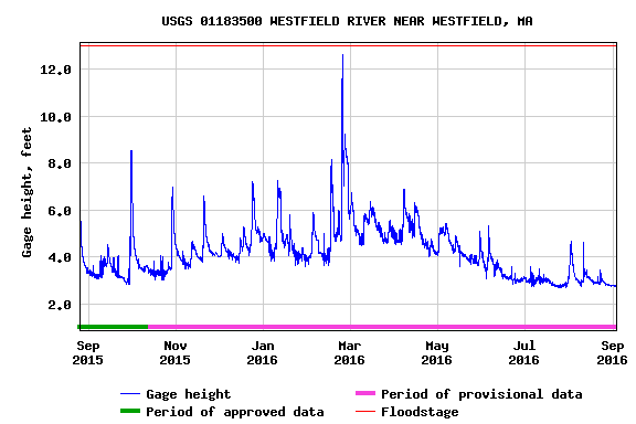
Back home, though, I began to rethink this decision. We're in a major drought, so the river should be low.  I verified this by checking a page from the National Weather Service for the USGS Westfield River Streamgage out of Westfield. Here's a screen shot:

Water depth at gauge is 2.8 ft

It shows the water level at the streamgage was 2.8 feet.  But what is the water depth at the ford? I would assume any ford is shallower, that's why it's a ford.  I stumbled across page where hiker described the water being up to his mid-thighs at the crossing.  I then found historic data for the streamgage on a USGS page. On that page, you can enter a range of dates to generate a hydrograph. Here's one for the past year:


From that graph, it was clear that the river depth at 2.8 feet was very, very low. It looks like it's normally about four or five feet deep at the streamgage, spiking after rains by a couple feet, in some cases more (it was over 12 feet deep in March).  

Robinson State Park
Confident the river would be no higher than mid-thigh, I threw an extra pair of sneakers in my pack I went back to MA 187 to follow the trail through Robinson State Park. The first part was lovely and easy to follow, following the top of the river bluff. And to think I nearly skipped this! 


I missed where the M-M turns left off of the main path to head down the river, and had to use the gps to bushwhack down to the trail. I mumbled a statement of gratitude to the guy who posted his gps track online. As the trail dipped down to the shoreline it became extremely overgrown, although I was able to follow it (barely).  Don't try to cross the river prematurely, although it's tempting. Follow the blazes to the end (gps track highly recommend so you know you're at the ford). 


The ford. The shallows angle to the right. 

This way straight across is deeper. The shallows angle to the far right of the photo.
With the low water, there was a nice gravel bar to linger and let the dog swim. The crossing looked pretty shallow. There were lots of freshwater clam shells along the shore, some dumped in piles where the muskrats left them.
Mussels shells, probably left by a muskrat
After switching to my sneakers, I set out across the water. It was nice and only about a foot deep. Minnows swam about and there were some live clams in the bottom.

Live freshwater clam or mussel while crossing the Westfield River
I was so focused on taking pictures and enjoying the water I suddenly found myself in water above the knees. The clear water was deeper than it looked (but still not a problem).  I had headed straight across the river towards the blazed tree, while the shallows angled off to the right. I meandered over to the gravel bar ford and walked around. The entire way across, if you stay on the gravel bar, was at the most 1.5 feet deep. If you go straight across the river to the blaze, it's up to 3 feet deep, about the same as the USGS river gage.

The blue line is the gravel bar, about 1.5 feet less than the USGS streamgage.
The red line is about the same depth as the USGS streamgage.
In summary, the USGS streamgage is a great resource to find out how deep the river crossing is. Take the reported river depth at the gauge and subtract 1.5 feet to estimate the shallowest possible crossing if you choose your footing carefully to follow the gravel bar, or just use the gauge depth to estimate the deepest water going straight across from blaze to blaze. Keep in mind there is also a pretty good current, and as the water gets deeper, it can really sweep you off your feet.

Crossing to the other side, I was greeted by some Allegheny Monkey Flower, a native of wet places that has flowers that look like they're grinning.  Now I can start Section 3.


Allegheny Monkey Flower