Day 2 of the New Hampshire M-M Trail started at Widow Gage Town Forest in Fitzwilliam and I meant to stop after the Troy road walk, leaving Gap Mountain for Day 3. But by the end of the day I had done both hikes and was at the foot of Mt. Monadnack.
Clearly a lot of love has gone into Widow Gage Forest by the Fitzwilliam Conservation Commission. They have an excellent trail map to go along with the well-marked trails. Landmarks labeled on the map include "curved stone wall" and "massive rock pile" so you have something there to look forward to. They've installed nice custom metal signs, too. Nicely done.
Before long, the access trail meets back up with the M-M Trail and the slow climb up Little Monadnack begins. This way up wasn't steep at all. This was a coffee-sipping stroll. I looked forward to getting to the top and finally getting some views.
And the view of Mt. Monadnock from the summit was well worth it. The last view of the mountain was at the Richardson-Zlogar cabin, and the trail is definitely a lot closer to the finish line than it was then. How exciting!
It must be amazing when it's in bloom. The only other time I've seen wild Rosebay Rhododendron in New England was in Patchaug State Forest in Connecticut, where it was growing in a swamp and a boardwalk takes you through the grove. Although the grove in New Hampshire wasn't exactly swampy, it was low and probably gets a lot of water seeping out of Little Monadnock.
 |
| Well-weathered summit marker |
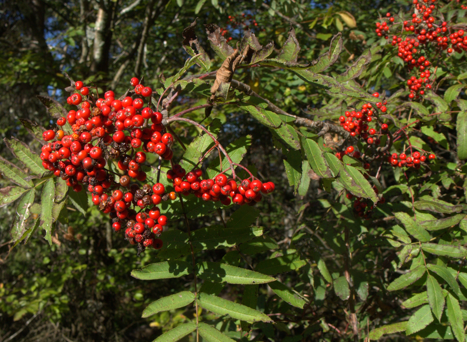
Up at the top, there were striking clumps of mountain ash berries only a few feet from the summit marker. Mountain ash makes me think of the White Mountains further north. It's not something I see hiking in Connecticut. It's something I see on vacation.
 |
| Mountain Ash |
Hiking with the cast on was working out OK. I was worried my hand would swell up or something and I'd have to bail out, but it was good. Better than being at work trying to type. As long as I didn't have any scrambles, the cast didn't interfere with hiking too much. I will note that wrists are highly underrated. You don't realize how well they rotate your hand into the correct position to do things like turn door knobs or put a cell phone in your pocket until you can't move your wrist.
 |
| Hiking with a cast. |
After the summit, there were a few more views, like the one below. Notice how the ledge drops off steeply and how far down the tops of the trees are off to the left. Where the trail was headed.
 |
| Another view, with the trail going straight down the ledge. |
I walked down the ledge OK (good thing it wasn't wet), until the last fifteen feet or so, which was a seemingly impossible scramble. Sure, my 20-year-old cast-less self probably would have laughed at this, but it hasn't been the 1980's in a very long time.
 |
| It's steeper than it looks, I swear. That's my pack at the bottom. |
I sat at the top of this scramble for a good twenty minutes trying to figure out how to get down without breaking a leg. Never make a rash decision out in the middle of nowhere, right? I rolled my pack down, and was then fully committed. But I still couldn't figure it out. The rock was smooth and mossy and slick with pine needles and leaves. And I couldn't use my right hand to grip anything. This was the worst scramble of the entire NET, and I went down the Chauncey scramble before it was rerouted, so that's saying something. But the Chauncey scramble actually had nice squared places to put your toes and hang on with your hands once you studied it. This had nothing. I didn't even have any rope. I had visions of breaking an ankle (which I've already done three times, twice going out for the school bus and another time up a mountain like this one) and the embarrassment of getting hauled down the mountain. And then I'd be wearing two casts!
 |
| Looking back. |
I finally chose a spot off to the side, cleared out some potential finger holds at the top of the rock, then got on my stomach and slide down that way about four feet to a small ledge just a couple inches wide. I was terrified my feet wouldn't stop at the ledge because everything was so rounded and mossy, but they did. I halted there for a minute or two, carefully clearing leaves and needles off of the ledge, then finally made a move down to another marginal ledge, then another and I was down. Oh thank goodness. Later that day I opened up the M-M Guidebook to see what it said about that insanity, and it simply told hikers to "slide down over a nearly vertical, small rock face." Slide down? Is that a thing? Apparently it is. If I had known that was the normal way to get down and my hand wasn't in a cast I'm not sure if I would have tried it or not. I almost want to go back and try to master that skill. Almost. At any rate, that's a good spot for a bypass trail if possible. Next time I hike in New Hampshire I'm bringing rope.
 |
| Sarsaparilla |
Relieved to still be on two unbroken legs, I meandered on down the trail and came to the next challenge, which was finding the blazes across a very wide powerline clearing. It was kind of like a scavenger hunt. Are they down this way? Nope. How about this way? Nada. Oh, hey there's one. Ok where's the next one? The blazes were all on rocks and didn't go down the various roads and paths like I expected, but climbed up rocky features and then plunged back down into brush. It wasn't a big deal because it was still morning and I had all day and was in no rush. If dark was approaching it could have been a problem.
 |
| There are worse things than hunting for blazes in a beautiful area. |
Before long the trail came out onto a rough dirt road and followed the road all the way into Troy. The road gradually improved as it continued east and eventually evolved into Prospect Street.
 |
| Prospect Street, still a dirt 4WD road, passing a beaver pond |
It was a pleasant morning walk down the hill. The scattered houses became more frequent as the road descended and approached Troy.
 |
| Upper Prospect Street |
 |
| Concerned chickens. |
 |
| Troy Railroad Depot, where hikers used to start their Monadnock climb. |
Back in the day, people like Henry David Thoreau used to take the train to the Troy Railroad Depot, where they would get off to begin their climb up Mt. Monadnock. The train station is wonderfully preserved, although the doors were locked as I walked by.
 |
| Water Street |
I turned east onto Water Street when I got to Troy. I didn't see any blazes on Water Street and it could be the trail technically goes up to the next street before turning east. The night before I had studied the maps and it seemed like there were a couple different versions of what street you were supposed to go down. This was the fastest, so that's what I did.
 |
| View from Water Street |
There sadly didn't seem to be any shops open, but it was a Monday, and it seems that many of the restaurants and shops are closed on Mondays. I turned right onto Highway 12 and began following the white blazes down the sidewalk through a well-kept neighborhood. At one point there was a pickup truck parked up on the sidewalk and as I passed it a couple of older gentlemen leaning against the truck gave greetings and asked how far I was going. Everyone is so nice.
 |
| Highway 12 |
My plan was to complete the road walk at the end of Quarry Road and call it a day, leaving Gap Moutain for the next day before heading home to Connecticut. Shortly after turning onto Quarry Road, my husband drove up and I was able to ditch the pack for the rest of the road walk. He drove up the road and explored a spring house located where the trail leaves Quarry Road. The spring house protects the water coming up out of the ground and there's a hole in the floor where people can fill containers with water. The water looked pretty stagnant, though.
 |
| Spring House at the end of Quarry Road |
I caught up with my husband at the spring house and it was only 1:30 pm. I didn't want to stop. My arm was doing fine in the cast, and Monadnock was getting so close. My husband was up for a hike, so he left me there with a lightened pack and drove off to the north parking area for Gap Mountain. The plan was this: I'd climb up from the west and he'd climb up from the east and we would meet at the summit and go down together. That way, if there were any steep scrambles like that "slide" on Little Monadnock, I wouldn't have to do it alone in a cast.
 |
| Spring House |
Gap Mountain was a much steeper climb than the ascent up Little Monodnock had been earlier in the day, and the afternoon sun was beating down on the west side of the slope. My photos turned out to be nothing but sun glare and deep shadows. The cast on my arm was getting itchy. I began to question my judgement at continuing on when I was in such couch-potato physical condition (in my defense, I was lame for the past year). But Monadnock!
 |
| Wolf trees and stone walls from an old farm. |
Gap Mountain appears to be a very popular place to hike, although not on Mondays in September because I only saw one other set of hikers the entire day. A huge amount of work has gone into improving the trail and addressing erosion, with a number of stairs and water bars in the steeper areas.
Signs of former farmland abounded, especially rock walls lined with big old wolf trees from when the land was an open pasture. About half way up there were the skeletal remains an old apple orchard interspersed with pioneering gray birch.
 |
| Old apple orchard converting back to forest. |
After several stops to catch my breath as the path steepened towards to the top, it leveled off and opened up. Wow. What a joy to reach the first summit! Look at Mt. Monadnock, no longer off in the distance, but
right there.
 |
| Middle Summit - Wow! |
After snapping a few photos I continued on to the north summit, which was very close by and easy to get to. The view was even better. Holy cow. No wonder a lot of people climb Gap Mountain.
 |
| North Summit - Even better! |
I was still taking pictures when my husband joined me at the top. Great timing! That worked out well. We lingered for twenty minutes or so just enjoying the view, the cool fall breeze, and the warm sun. Then we headed down the hill.
 |
| Winterberry at the summit |
In contrast to the hot and sunny west slope, the east side of Gap Mountain was in late afternoon shadow and it was darker and cooler heading downhill. The trail was well-built and although rather steep, there were no major scrambles or spots with bad footing. A pleasant descent.
 |
| Some of the rock work at Gap Mountain |
At some point the trail begins to be called the Royce Trail. I'm not sure if that starts at the top of Gap Mountain or what, but the local Royce Trail name for the M-M continues on up Mt. Monadnack a good ways before the M-M begins following the White Arrow Trail.
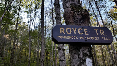 |
| Royce Trail = M-M Trail on Gap Mountain & Mt. Monadnock |
I was surreptitiously checking the trail map as we headed down the mountain and ascertained that it was 0.8 miles from the north parking lot, where the car was parked, to Route 124 at the base of Mt. Monadnock. So close!
 |
| Getting so close! |
So you won't be surprised to hear that when we got to the parking lot turnoff I just kept going straight and said, "Pick me up on 124!"
 |
| Old pastureland |
It was a nice last bit of walking along a well-used trail through the lush forest and before long I came out onto the highway. Whoohoo! There's a pull-off where the M-M crosses the highway, but it's full of 'no parking' signs. So that's inconvenient. But sitting in a car for a few minutes seemed OK.
 |
| Route 124 and the foot of Mt. Monadnack P.S No Parking |
There! All ready for Monadnock, which would have to wait until I got my cast off.
I was pretty tired that night. I don't usually get too focused on stats like mileage or elevation, but I added up the total for the day and it was 9.6 miles with more that 2,000 feet in elevation gain. That was a lot for this couch potato. So, so tired!


No comments:
Post a Comment