Here's a little slideshow to the sound of Van Morrison, starting in Guilford last January and ending in Suffield last month. I have another version with captions in case you're wondering what a particular plant is or where a photo was taken. Many of these pictures are in the blog.
Sunday, November 11, 2012
Saturday, October 27, 2012
Higby Before the Storm
 |
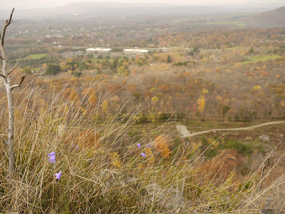
| The air was so thick you can barely see West Peak in the distance. |
Saturday before the Hurricane Sandy was set to hit, the tropical air was thick, warm, and quiet. A group of us set out to enjoy the last of the fall hiking before making final preparation for the massive storm that was predicted. And so now I'm enjoying the last of the electricity, heat and water as the storm approaches and will leave you with these pictures. That may be it for awhile on the trails, depending on what kind of mess Sandy leaves behind. [update: lost power for six days]
 |
| The popular first viewpoint. |
 |
| Looking towards the second Higby peak |
 |
| Don't step backwards. |
 |
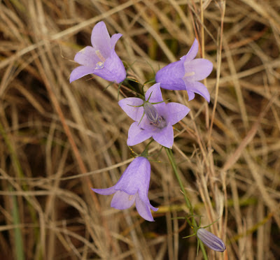
| Delicate Harebell flowers in bloom on the edge of the cliff. |
 |
| Harebell - a native species |
 |
| Bayberries - the stuff they make candles from |
 |
| Bayberry growing on the cliff edge |
Friday, October 26, 2012
East River Preserve - Guilford
 |
| New trailhead on Clapboard Hill Road |
And we're back in Guilford, where we started this adventure last January, because they've completed another 1.5 mile of trail heading south and I want to hike it before Frankenstorm Sandy gets here. I saw a CFPA notice about the new section, and there's a map online here showing the extension from Sullivan Drive down to Duck Hole Road. So that's where I was headed when I passed the unmistakeable NET trail markings on Clapboard Hill Road. Yippee, they got the trail even farther than they said!
 |
| Trail map based on my gps route |
This was great timing for a hike in Guilford, since their fall foliage was not as advanced as further north and it was like going back in time a week or so.
 |
| Random ruins along the trail |
This section of trail is lovely, with some of the most perfectly painted trail blazes I think I have ever seen. It is not easy to paint a perfect rectangle on rough bark, but these were perfect.
 |
| Lots of bolders |
Guilford has the only part of the mainline NET that is not on the Metacomet traprock ridge. This rock is more what I'm used to -- gneiss and schist. And there is lots of it.
 |
| Skirting the meadows |
There is a series of meadows that the trail eventually comes out onto, following near the edge. It's all very tastefully well marked.
 |
| East River |
 |
| East River |
 |
| Bridge crossing off of Foote Bridge Road |
 |
| Four-foot diameter White Oak - the state tree |
 |
| Sullivan Drive |
 |
| Heading back from Sullivan Drive |
 |
| More random ruins - an old breached dam (back near the beginning) |
 |
| East River overlook. This is back near the car. |
 |
| Autumn Snooze - the joy of not racing down the trail |
Monday, October 22, 2012
West Suffield Mountain
 |
| ...but the "Metacomet Trail" at heart |

Since I'm not a backpacking thru-hiker, and don't do the road sections, I'm treating the "Blue Trail" as though it were still the official Metacomet Trail (and New England Trail). You will not find any information about this trail in your CFPA CT Walk Book, but I've included a few maps here.
The trailhead is at the Howard H. Alcorn Wildlife Preserve just across the street from the Suffield Mountain trailhead. I was not planning on hiking the Blue Trail on the same day as Suffield Mountain, but the it was right there across the street. Although it was late in the day, it could not wait. The end of the trail! (for Connecticut, anyway). I figured I could cover the four mile round trip before sunset if I moved quickly.
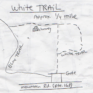
I picked up a trail map kindly supplied at the start of the trail (scanned at the bottom of this post) and started up the White Trail, quickly passing another chimney, and very shortly joined the blue. The map at left is from my gps route (click it to enlarge).
 |
| Chimney on the White Trail |
There is supposed to be the remains of another cabin along the Blue Trail, but I couldn't find it and suspect it may be another casualty of the massive powerline work that's going on in a couple of towns up here. Part of the trail near the powerlines was likewise obliterated, but turn right along the powerlines for a bit and look for the blue to re-enter the woods on the left. The top of West Suffield Mountain is not far after that.
 |
| Gazing out over Massachusetts from West Suffield Mountain |
It was a fast walk along the ridge in search of the end, racing with the sinking sun and trending down the hill, when all of the sudden there it was. Two horizontal blue blazes.
 |
| So this is how it all ends. |
 |
| Sumac |
On the way back, the low light of the sinking sun made for some nice fall foliage shots.
 |
| Sweet Fern (not actually a fern) |
 |
| Red Oak |
The Connecticut NET journey is not over! There's a new section down in Guilford that was just completed in 2012, and then there's that long section of the Mattabesett Trail that looks like a spur off the mainline NET. And after that, there's always Massachusetts.
I will leave you with the hand-out maps for West Suffield Mountain:
Suffield Mountain
Last official section of the New England Trail in Connecticut! Don't get too excited, though, because there's a demoted section of trail after this that will be the "real" end for me. It's also the last gasp of fall, at least in northern Connecticut. Great timing!
This was a long drive for me, about an hour and a half, and involved a moment of confusion when the Droid took me into Massachusetts. Wha? And then it dawned on me that I was driving through that little piece of land that Massachusetts stole from us, you know, the part that juts down into Connecticut. And just like that all the plates were Mass plates. I wondered if the people here pronounce their R's.
Before long the road swung back into Connecticut and I found a small pull-off to park the car on Phelps Road near the intersection with Rt 168. A sign announced the land as Spencer Woods and the blue blazes headed quickly up the hill.
I believe there is an error in the CT Walkbook with regard to the distances on this mountain. According to the mileage given, it's 4.0 miles to the town line via Copper Mountain, but only 1.2 miles to the town line via Suffield Mountain, yet the town line is nearly halfway between the two trailheads. I believe it is 2.2 miles, or slightly longer, to the town line from Suffield Mountain, but only 2.5 to 3.0 miles to the town line via Copper Mountain.
Shortly after beginning the hike, there is a well-worn but unmarked path on the left that leads quickly to yet another chimney. This one had some sort of seats built around it, but was pretty overgrown. A bit further on there is a big routered sign for the George A. Harmon woodlot (which would explain the dense new undergrowth and rotting stumps), and a trail heading down the slope that was once blazed orange. They probably used cheap spray paint, because the blazes are nearly gone.
And in less that two miles of hiking along the ridge there's a beautiful overlook accompanied by a mysterious sign informing you of the latitude and longitude, as well as a bench and a trail logbook.
Trail logbooks are fun. Sort of like letterbox logbooks but without the rubber stamps or the need to actually find the logbook, which means that everyone can sign it, not just those of us who have joined the cult. This book was nicely maintained and just full of signatures.
After the overlook, it was just another 15 minutes of hiking to the town line, where I left off on my previous trip. I did manage to find yet another balloon on the trail. It was a wedding balloon, high up on Suffield Mountain.
I got back to the car at 2:45 pm and that's where I had planned on leaving off for the day. From the intersection of Phelps Road and Rt 168, the trail sadly follows the road for about 2 1/2 miles to Massachusetts and the Metacomet-Monadnock portion of the New England Trail. Because I'm just a day hiker and not doing the road walks, this should end the Connecticut portion of the New England Trail for me. It doesn't. There are two more miles of demoted trail that will take me within a quarter mile of the border. And rather than drive home as I had planned, I set out to finish the job and find what for me is the 'real' end of the trail. But that will be another post.
This was a long drive for me, about an hour and a half, and involved a moment of confusion when the Droid took me into Massachusetts. Wha? And then it dawned on me that I was driving through that little piece of land that Massachusetts stole from us, you know, the part that juts down into Connecticut. And just like that all the plates were Mass plates. I wondered if the people here pronounce their R's.
 |
| Another chimney |
I believe there is an error in the CT Walkbook with regard to the distances on this mountain. According to the mileage given, it's 4.0 miles to the town line via Copper Mountain, but only 1.2 miles to the town line via Suffield Mountain, yet the town line is nearly halfway between the two trailheads. I believe it is 2.2 miles, or slightly longer, to the town line from Suffield Mountain, but only 2.5 to 3.0 miles to the town line via Copper Mountain.
Shortly after beginning the hike, there is a well-worn but unmarked path on the left that leads quickly to yet another chimney. This one had some sort of seats built around it, but was pretty overgrown. A bit further on there is a big routered sign for the George A. Harmon woodlot (which would explain the dense new undergrowth and rotting stumps), and a trail heading down the slope that was once blazed orange. They probably used cheap spray paint, because the blazes are nearly gone.
 |
| Now you know where you are. |
Trail logbooks are fun. Sort of like letterbox logbooks but without the rubber stamps or the need to actually find the logbook, which means that everyone can sign it, not just those of us who have joined the cult. This book was nicely maintained and just full of signatures.
 |
| Trail logbook |
 |
| Pages and pages of this stuff. |
 |
| A beautiful view! |
 |
| Heublein Tower in the distance. |
 |
| Another balloon |
I got back to the car at 2:45 pm and that's where I had planned on leaving off for the day. From the intersection of Phelps Road and Rt 168, the trail sadly follows the road for about 2 1/2 miles to Massachusetts and the Metacomet-Monadnock portion of the New England Trail. Because I'm just a day hiker and not doing the road walks, this should end the Connecticut portion of the New England Trail for me. It doesn't. There are two more miles of demoted trail that will take me within a quarter mile of the border. And rather than drive home as I had planned, I set out to finish the job and find what for me is the 'real' end of the trail. But that will be another post.
Thursday, October 18, 2012
Copper Mountain, East Granby
 |
| Doll's Eye Baneberry |
 |
| Junction with the Red Trail |
 |
| Asters and Maple |
Just past the red trail the blue blazes head up a steeper section of trap rock to a spectacular overlook. Finally! After the view-less hike along Hatchet Hill, this is just what I was looking for. And more. It was one of those, "Wow! I mean wow!" moments.
 |
| Copper Mountain |
 |
| View south along the Talcott Mountain ridge and Heublein Tower |
 |
| USGS Survey Marker |
 |
| View northwest towards Massachusetts |
After the breathtaking fall views, the trail continued along the ridge for quite some ways with partial views, eventually coming to a second lookout almost as good as the first. The remains of Old-Newgate Prison are visible from the ridge.
 |
| Looking down on Old New-Gate Prison |
 |
| "Squirrel!" |
 |
| Nice to see fewer houses and more trees |
 |
| Slug trails on trap rock |
 |
| East Granby - Suffield granite boundary monument |
Near the granite monument are a couple of much older markings that I assume are previous attempts to mark the town line, which they would naturally do up here on top of the ridge. First is a pile of rocks. It's funny when you read old deeds or survey maps and they define property lines by things like "the pile of rocks." What if someone from East Granby decided to just move the pile of rocks over and take part of Suffield?
 |
| Old boundary marker |
 |
| Another old boundary marker |
 |
| View at the East Granby - Suffield town line |
 |
| Interesting spot for a mushroom to grow. |
Subscribe to:
Comments (Atom)


